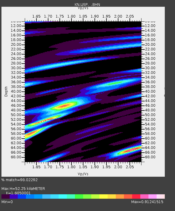
USP KN.USP - Earthquake Result Viewer
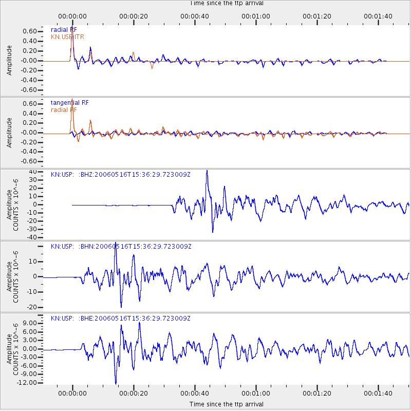
Earthquake location: Northern Sumatra, Indonesia
Earthquake latitude/longitude: 0.1/97.1
Earthquake time(UTC): 2006/05/16 (136) 15:28:25 GMT
Earthquake Depth: 12 km
Earthquake Magnitude: 6.6 MB, 6.8 MS, 6.8 MW, 6.8 MW
Earthquake Catalog/Contributor: WHDF/NEIC
Network: KN Kyrgyz Seismic Telemetry Network
Station: USP KN.USP
Lat/Lon: 43.27 N/74.50 E
Elevation: 740 m
Distance: 47.5 deg
Az: 337.666 deg
Baz: 148.652 deg
Ray Param: 0.06994953
Estimated Moho Depth: 52.25 km
Estimated Crust Vp/Vs: 1.69
Assumed Crust Vp: 6.306 km/s
Estimated Crust Vs: 3.742 km/s
Estimated Crust Poisson's Ratio: 0.23
Radial Match: 98.02292 %
Radial Bump: 255
Transverse Match: 88.20548 %
Transverse Bump: 400
SOD ConfigId: 2669
Insert Time: 2010-03-08 22:21:04.261 +0000
GWidth: 2.5
Max Bumps: 400
Tol: 0.001

Signal To Noise

ChannelStoNSTALTA
KN:USP: :BHN:20060516T15:36:29.723009Z48.2338641.5996063E-63.3163552E-8
KN:USP: :BHE:20060516T15:36:29.723009Z15.5616198.9909054E-75.777616E-8
KN:USP: :BHZ:20060516T15:36:29.723009Z45.6606143.5095027E-67.686061E-8
Arrivals
Ps6.0 SECOND
PpPs21 SECOND
PsPs/PpSs27 SECOND