You are here: Home > Network List > TA - USArray Transportable Network (new EarthScope stations) Stations List
> Station R33M Jennings River, BC, CAN > Earthquake Result Viewer
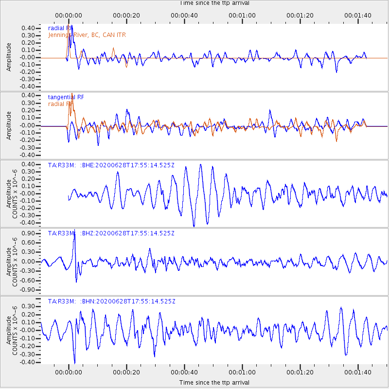
R33M Jennings River, BC, CAN - Earthquake Result Viewer
*The percent match for this event was below the threshold and hence no stack was calculated.
| Earthquake location: |
Dodecanese Islands, Greece |
| Earthquake latitude/longitude: |
36.7/28.3 |
| Earthquake time(UTC): |
2020/06/28 (180) 17:43:28 GMT |
| Earthquake Depth: |
62 km |
| Earthquake Magnitude: |
5.5 Mww |
| Earthquake Catalog/Contributor: |
NEIC PDE/us |
|
| Network: |
TA USArray Transportable Network (new EarthScope stations) |
| Station: |
R33M Jennings River, BC, CAN |
| Lat/Lon: |
59.39 N/130.97 W |
| Elevation: |
1437 m |
|
| Distance: |
82.7 deg |
| Az: |
349.454 deg |
| Baz: |
16.701 deg |
| Ray Param: |
$rayparam |
*The percent match for this event was below the threshold and hence was not used in the summary stack. |
|
| Radial Match: |
74.41542 % |
| Radial Bump: |
400 |
| Transverse Match: |
39.848373 % |
| Transverse Bump: |
310 |
| SOD ConfigId: |
21709731 |
| Insert Time: |
2020-07-12 18:02:49.851 +0000 |
| GWidth: |
2.5 |
| Max Bumps: |
400 |
| Tol: |
0.001 |
|
Signal To Noise
| Channel | StoN | STA | LTA |
| TA:R33M: :BHZ:20200628T17:55:14.525Z | 3.1525738 | 3.7935786E-7 | 1.2033274E-7 |
| TA:R33M: :BHN:20200628T17:55:14.525Z | 1.8279963 | 1.6113385E-7 | 8.814781E-8 |
| TA:R33M: :BHE:20200628T17:55:14.525Z | 1.4842619 | 1.3609613E-7 | 9.1692804E-8 |
| Arrivals |
| Ps | |
| PpPs | |
| PsPs/PpSs | |


