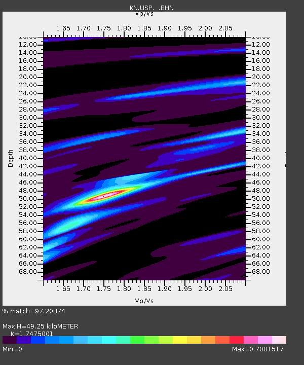
USP KN.USP - Earthquake Result Viewer
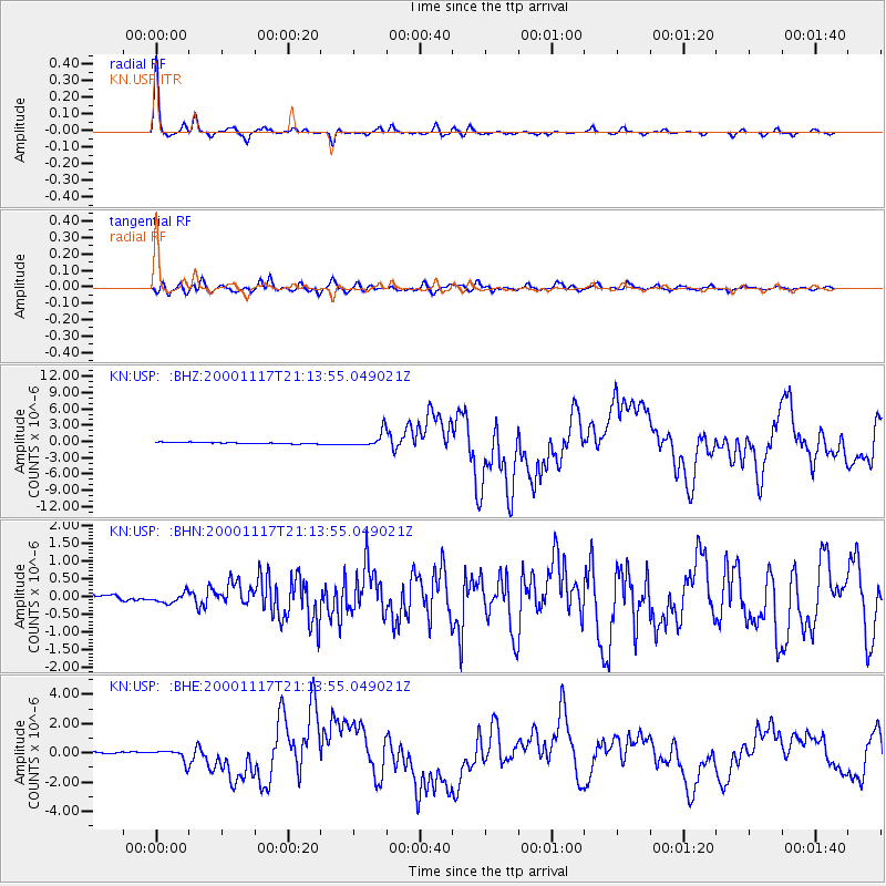
Earthquake location: New Britain Region, P.N.G.
Earthquake latitude/longitude: -5.5/151.8
Earthquake time(UTC): 2000/11/17 (322) 21:01:56 GMT
Earthquake Depth: 33 km
Earthquake Magnitude: 6.2 MB, 8.0 MS, 7.6 MW, 6.9 ME
Earthquake Catalog/Contributor: WHDF/NEIC
Network: KN Kyrgyz Seismic Telemetry Network
Station: USP KN.USP
Lat/Lon: 43.27 N/74.50 E
Elevation: 740 m
Distance: 84.5 deg
Az: 314.293 deg
Baz: 102.719 deg
Ray Param: 0.045364495
Estimated Moho Depth: 49.25 km
Estimated Crust Vp/Vs: 1.75
Assumed Crust Vp: 6.306 km/s
Estimated Crust Vs: 3.609 km/s
Estimated Crust Poisson's Ratio: 0.26
Radial Match: 97.20874 %
Radial Bump: 217
Transverse Match: 87.89653 %
Transverse Bump: 400
SOD ConfigId: 3744
Insert Time: 2010-03-08 22:21:51.033 +0000
GWidth: 2.5
Max Bumps: 400
Tol: 0.001

Signal To Noise

ChannelStoNSTALTA
KN:USP: :BHN:20001117T21:13:55.049021Z1.22267021.3267415E-71.085118E-7
KN:USP: :BHE:20001117T21:13:55.049021Z4.8064443.954587E-78.227677E-8
KN:USP: :BHZ:20001117T21:13:55.049021Z11.0987441.3872005E-61.2498717E-7
Arrivals
Ps6.0 SECOND
PpPs21 SECOND
PsPs/PpSs27 SECOND