You are here: Home > Network List > US - United States National Seismic Network Stations List
> Station DGMT Dagmar, Montana, USA > Earthquake Result Viewer
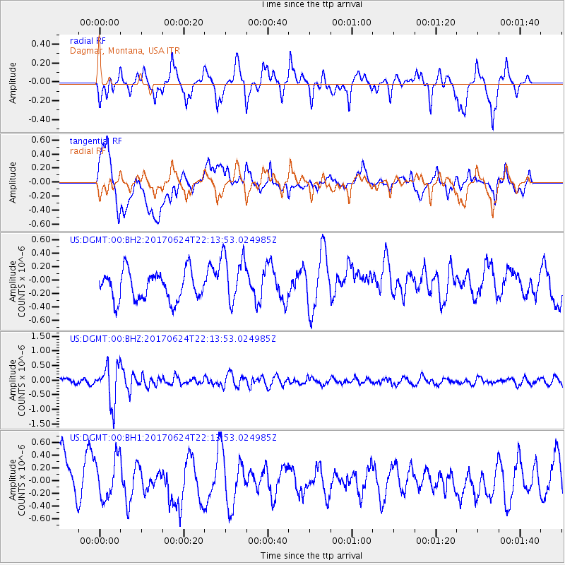
DGMT Dagmar, Montana, USA - Earthquake Result Viewer
*The percent match for this event was below the threshold and hence no stack was calculated.
| Earthquake location: |
Eastern Honshu, Japan |
| Earthquake latitude/longitude: |
35.8/137.6 |
| Earthquake time(UTC): |
2017/06/24 (175) 22:02:16 GMT |
| Earthquake Depth: |
10 km |
| Earthquake Magnitude: |
5.2 Mww |
| Earthquake Catalog/Contributor: |
NEIC PDE/us |
|
| Network: |
US United States National Seismic Network |
| Station: |
DGMT Dagmar, Montana, USA |
| Lat/Lon: |
48.47 N/104.20 W |
| Elevation: |
0.0 m |
|
| Distance: |
79.7 deg |
| Az: |
36.599 deg |
| Baz: |
313.27 deg |
| Ray Param: |
$rayparam |
*The percent match for this event was below the threshold and hence was not used in the summary stack. |
|
| Radial Match: |
53.713295 % |
| Radial Bump: |
372 |
| Transverse Match: |
45.971424 % |
| Transverse Bump: |
400 |
| SOD ConfigId: |
2140511 |
| Insert Time: |
2017-07-08 14:04:40.934 +0000 |
| GWidth: |
2.5 |
| Max Bumps: |
400 |
| Tol: |
0.001 |
|
Signal To Noise
| Channel | StoN | STA | LTA |
| US:DGMT:00:BHZ:20170624T22:13:53.024985Z | 5.7539415 | 6.7159226E-7 | 1.16718645E-7 |
| US:DGMT:00:BH1:20170624T22:13:53.024985Z | 0.63908696 | 3.20465E-7 | 5.0144195E-7 |
| US:DGMT:00:BH2:20170624T22:13:53.024985Z | 1.7966897 | 3.8235726E-7 | 2.1281205E-7 |
| Arrivals |
| Ps | |
| PpPs | |
| PsPs/PpSs | |


