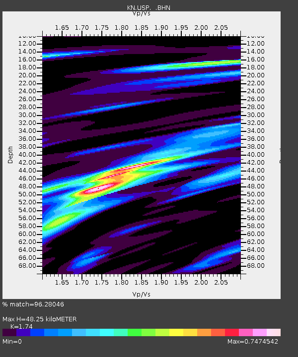
USP KN.USP - Earthquake Result Viewer
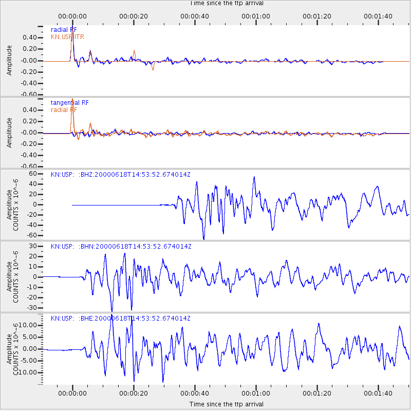
Earthquake location: South Indian Ocean
Earthquake latitude/longitude: -13.8/97.5
Earthquake time(UTC): 2000/06/18 (170) 14:44:13 GMT
Earthquake Depth: 10 km
Earthquake Magnitude: 6.8 MB, 7.8 MS, 7.8 MW, 7.6 MW
Earthquake Catalog/Contributor: WHDF/NEIC
Network: KN Kyrgyz Seismic Telemetry Network
Station: USP KN.USP
Lat/Lon: 43.27 N/74.50 E
Elevation: 740 m
Distance: 60.6 deg
Az: 340.906 deg
Baz: 154.211 deg
Ray Param: 0.06145353
Estimated Moho Depth: 48.25 km
Estimated Crust Vp/Vs: 1.74
Assumed Crust Vp: 6.306 km/s
Estimated Crust Vs: 3.624 km/s
Estimated Crust Poisson's Ratio: 0.25
Radial Match: 96.28046 %
Radial Bump: 338
Transverse Match: 86.43862 %
Transverse Bump: 400
SOD ConfigId: 3744
Insert Time: 2010-03-08 22:22:02.905 +0000
GWidth: 2.5
Max Bumps: 400
Tol: 0.001

Signal To Noise

ChannelStoNSTALTA
KN:USP: :BHN:20000618T14:53:52.674014Z2.88925532.080569E-67.201056E-7
KN:USP: :BHE:20000618T14:53:52.674014Z3.06798348.036052E-72.619327E-7
KN:USP: :BHZ:20000618T14:53:52.674014Z34.072694.8640377E-61.4275474E-7
Arrivals
Ps5.9 SECOND
PpPs20 SECOND
PsPs/PpSs26 SECOND