You are here: Home > Network List > US - United States National Seismic Network Stations List
> Station HAWA Hanford, Washington, USA > Earthquake Result Viewer
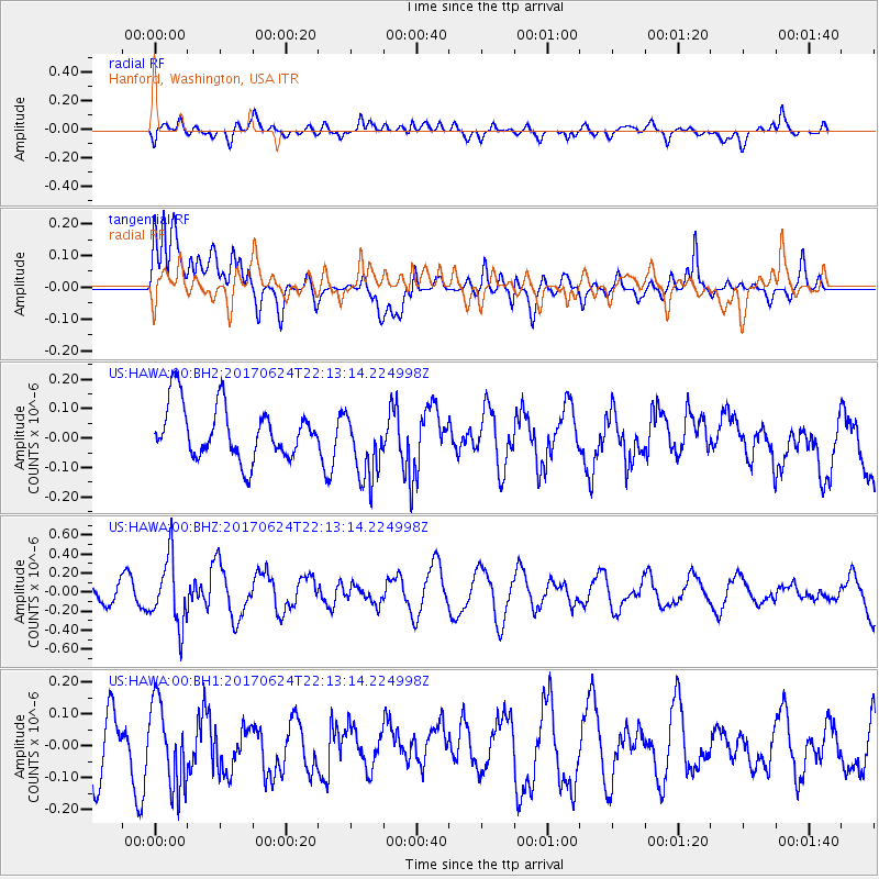
HAWA Hanford, Washington, USA - Earthquake Result Viewer
*The percent match for this event was below the threshold and hence no stack was calculated.
| Earthquake location: |
Eastern Honshu, Japan |
| Earthquake latitude/longitude: |
35.8/137.6 |
| Earthquake time(UTC): |
2017/06/24 (175) 22:02:16 GMT |
| Earthquake Depth: |
10 km |
| Earthquake Magnitude: |
5.2 Mww |
| Earthquake Catalog/Contributor: |
NEIC PDE/us |
|
| Network: |
US United States National Seismic Network |
| Station: |
HAWA Hanford, Washington, USA |
| Lat/Lon: |
46.39 N/119.53 W |
| Elevation: |
364 m |
|
| Distance: |
72.8 deg |
| Az: |
44.935 deg |
| Baz: |
303.965 deg |
| Ray Param: |
$rayparam |
*The percent match for this event was below the threshold and hence was not used in the summary stack. |
|
| Radial Match: |
43.86073 % |
| Radial Bump: |
400 |
| Transverse Match: |
55.504715 % |
| Transverse Bump: |
400 |
| SOD ConfigId: |
2140511 |
| Insert Time: |
2017-07-08 14:04:53.472 +0000 |
| GWidth: |
2.5 |
| Max Bumps: |
400 |
| Tol: |
0.001 |
|
Signal To Noise
| Channel | StoN | STA | LTA |
| US:HAWA:00:BHZ:20170624T22:13:14.224998Z | 2.684522 | 3.4915323E-7 | 1.3006161E-7 |
| US:HAWA:00:BH1:20170624T22:13:14.224998Z | 1.656983 | 1.3024885E-7 | 7.860603E-8 |
| US:HAWA:00:BH2:20170624T22:13:14.224998Z | 1.303715 | 1.1806393E-7 | 9.055962E-8 |
| Arrivals |
| Ps | |
| PpPs | |
| PsPs/PpSs | |


