You are here: Home > Network List > US - United States National Seismic Network Stations List
> Station LAO LASA Array, Montana, USA > Earthquake Result Viewer
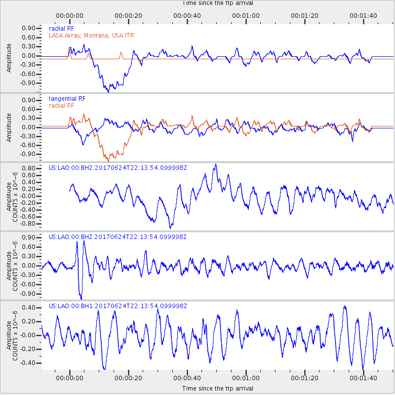
LAO LASA Array, Montana, USA - Earthquake Result Viewer
*The percent match for this event was below the threshold and hence no stack was calculated.
| Earthquake location: |
Eastern Honshu, Japan |
| Earthquake latitude/longitude: |
35.8/137.6 |
| Earthquake time(UTC): |
2017/06/24 (175) 22:02:16 GMT |
| Earthquake Depth: |
10 km |
| Earthquake Magnitude: |
5.2 Mww |
| Earthquake Catalog/Contributor: |
NEIC PDE/us |
|
| Network: |
US United States National Seismic Network |
| Station: |
LAO LASA Array, Montana, USA |
| Lat/Lon: |
46.69 N/106.22 W |
| Elevation: |
902 m |
|
| Distance: |
79.9 deg |
| Az: |
38.876 deg |
| Baz: |
312.182 deg |
| Ray Param: |
$rayparam |
*The percent match for this event was below the threshold and hence was not used in the summary stack. |
|
| Radial Match: |
42.33698 % |
| Radial Bump: |
400 |
| Transverse Match: |
47.8925 % |
| Transverse Bump: |
400 |
| SOD ConfigId: |
2140511 |
| Insert Time: |
2017-07-08 14:05:05.333 +0000 |
| GWidth: |
2.5 |
| Max Bumps: |
400 |
| Tol: |
0.001 |
|
Signal To Noise
| Channel | StoN | STA | LTA |
| US:LAO:00:BHZ:20170624T22:13:54.099998Z | 4.2692075 | 5.045043E-7 | 1.18172835E-7 |
| US:LAO:00:BH1:20170624T22:13:54.099998Z | 0.28147975 | 6.457354E-8 | 2.2940743E-7 |
| US:LAO:00:BH2:20170624T22:13:54.099998Z | 3.207443 | 5.449063E-7 | 1.6988807E-7 |
| Arrivals |
| Ps | |
| PpPs | |
| PsPs/PpSs | |


