You are here: Home > Network List > PE - Penn State Network Stations List
> Station PAGS PA Geological Survey > Earthquake Result Viewer
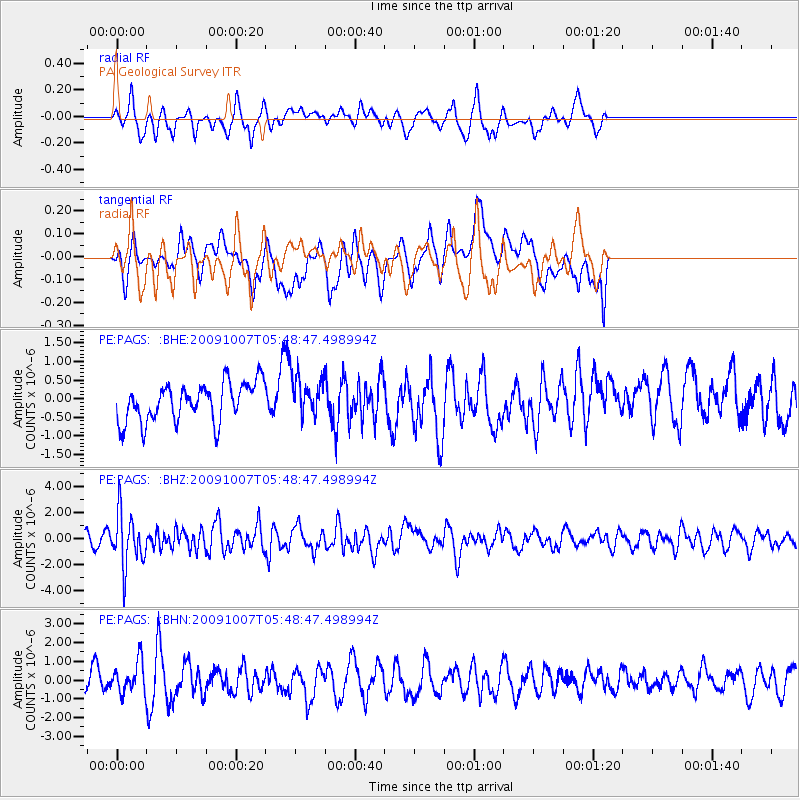
PAGS PA Geological Survey - Earthquake Result Viewer
*The percent match for this event was below the threshold and hence no stack was calculated.
| Earthquake location: |
Rat Islands, Aleutian Islands |
| Earthquake latitude/longitude: |
52.2/178.1 |
| Earthquake time(UTC): |
2009/10/07 (280) 05:38:37 GMT |
| Earthquake Depth: |
138 km |
| Earthquake Magnitude: |
5.6 MB, 5.6 MW, 5.6 MW |
| Earthquake Catalog/Contributor: |
WHDF/NEIC |
|
| Network: |
PE Penn State Network |
| Station: |
PAGS PA Geological Survey |
| Lat/Lon: |
40.23 N/76.72 W |
| Elevation: |
120 m |
|
| Distance: |
67.5 deg |
| Az: |
53.098 deg |
| Baz: |
319.949 deg |
| Ray Param: |
$rayparam |
*The percent match for this event was below the threshold and hence was not used in the summary stack. |
|
| Radial Match: |
49.44792 % |
| Radial Bump: |
376 |
| Transverse Match: |
43.035915 % |
| Transverse Bump: |
400 |
| SOD ConfigId: |
2622 |
| Insert Time: |
2010-02-26 14:56:14.612 +0000 |
| GWidth: |
2.5 |
| Max Bumps: |
400 |
| Tol: |
0.001 |
|
Signal To Noise
| Channel | StoN | STA | LTA |
| PE:PAGS: :BHZ:20091007T05:48:47.498994Z | 3.139131 | 1.973268E-6 | 6.2860323E-7 |
| PE:PAGS: :BHN:20091007T05:48:47.498994Z | 1.3074607 | 8.3489107E-7 | 6.3855924E-7 |
| PE:PAGS: :BHE:20091007T05:48:47.498994Z | 1.0720478 | 5.506664E-7 | 5.1365845E-7 |
| Arrivals |
| Ps | |
| PpPs | |
| PsPs/PpSs | |


