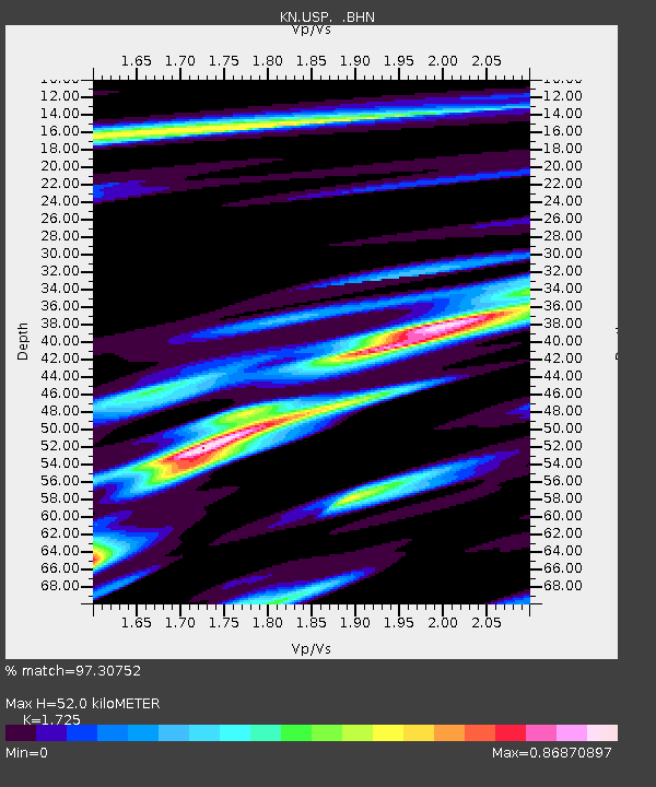
USP KN.USP - Earthquake Result Viewer
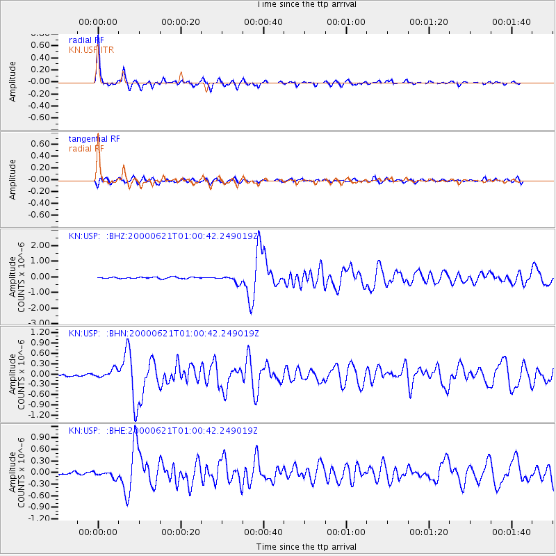
Earthquake location: Iceland
Earthquake latitude/longitude: 64.0/-20.8
Earthquake time(UTC): 2000/06/21 (173) 00:51:46 GMT
Earthquake Depth: 10 km
Earthquake Magnitude: 6.1 MB, 6.6 MS, 6.5 MW, 6.4 MW
Earthquake Catalog/Contributor: WHDF/NEIC
Network: KN Kyrgyz Seismic Telemetry Network
Station: USP KN.USP
Lat/Lon: 43.27 N/74.50 E
Elevation: 740 m
Distance: 54.3 deg
Az: 63.586 deg
Baz: 327.263 deg
Ray Param: 0.0655283
Estimated Moho Depth: 52.0 km
Estimated Crust Vp/Vs: 1.73
Assumed Crust Vp: 6.306 km/s
Estimated Crust Vs: 3.656 km/s
Estimated Crust Poisson's Ratio: 0.25
Radial Match: 97.30752 %
Radial Bump: 290
Transverse Match: 82.516525 %
Transverse Bump: 400
SOD ConfigId: 3744
Insert Time: 2010-03-08 22:22:33.204 +0000
GWidth: 2.5
Max Bumps: 400
Tol: 0.001

Signal To Noise

ChannelStoNSTALTA
KN:USP: :BHN:20000621T01:00:42.249019Z4.37055251.3384354E-73.062394E-8
KN:USP: :BHE:20000621T01:00:42.249019Z2.87578.871754E-83.0850764E-8
KN:USP: :BHZ:20000621T01:00:42.249019Z5.3465792.3976372E-74.484432E-8
Arrivals
Ps6.3 SECOND
PpPs21 SECOND
PsPs/PpSs28 SECOND