You are here: Home > Network List > TA - USArray Transportable Network (new EarthScope stations) Stations List
> Station E18K Tukpahlearik Creek, AK, USA > Earthquake Result Viewer
E18K Tukpahlearik Creek, AK, USA - Earthquake Result Viewer
*The percent match for this event was below the threshold and hence no stack was calculated.
| Earthquake location: |
Solomon Islands |
| Earthquake latitude/longitude: |
-9.5/156.1 |
| Earthquake time(UTC): |
2020/06/15 (167) 10:37:33 GMT |
| Earthquake Depth: |
10 km |
| Earthquake Magnitude: |
5.6 mb |
| Earthquake Catalog/Contributor: |
NEIC PDE/us |
|
| Network: |
TA USArray Transportable Network (new EarthScope stations) |
| Station: |
E18K Tukpahlearik Creek, AK, USA |
| Lat/Lon: |
67.42 N/160.60 W |
| Elevation: |
297 m |
|
| Distance: |
82.7 deg |
| Az: |
15.485 deg |
| Baz: |
223.006 deg |
| Ray Param: |
$rayparam |
*The percent match for this event was below the threshold and hence was not used in the summary stack. |
|
| Radial Match: |
66.09742 % |
| Radial Bump: |
400 |
| Transverse Match: |
62.34194 % |
| Transverse Bump: |
400 |
| SOD ConfigId: |
21709731 |
| Insert Time: |
2020-07-13 08:53:37.830 +0000 |
| GWidth: |
2.5 |
| Max Bumps: |
400 |
| Tol: |
0.001 |
|
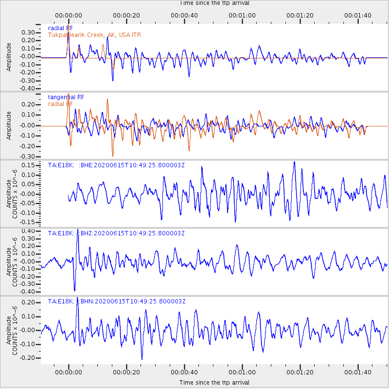
Signal To Noise
| Channel | StoN | STA | LTA |
| TA:E18K: :BHZ:20200615T10:49:25.800003Z | 3.3639479 | 1.6935061E-7 | 5.034282E-8 |
| TA:E18K: :BHN:20200615T10:49:25.800003Z | 3.1465368 | 8.5101206E-8 | 2.7045992E-8 |
| TA:E18K: :BHE:20200615T10:49:25.800003Z | 1.6303722 | 5.201249E-8 | 3.1902218E-8 |
| Arrivals |
| Ps | |
| PpPs | |
| PsPs/PpSs | |


