You are here: Home > Network List > TA - USArray Transportable Network (new EarthScope stations) Stations List
> Station E19K Redstone River, AK, USA > Earthquake Result Viewer
E19K Redstone River, AK, USA - Earthquake Result Viewer
| Earthquake location: |
Solomon Islands |
| Earthquake latitude/longitude: |
-9.5/156.1 |
| Earthquake time(UTC): |
2020/06/15 (167) 10:37:33 GMT |
| Earthquake Depth: |
10 km |
| Earthquake Magnitude: |
5.6 mb |
| Earthquake Catalog/Contributor: |
NEIC PDE/us |
|
| Network: |
TA USArray Transportable Network (new EarthScope stations) |
| Station: |
E19K Redstone River, AK, USA |
| Lat/Lon: |
67.46 N/157.23 W |
| Elevation: |
441 m |
|
| Distance: |
83.7 deg |
| Az: |
16.391 deg |
| Baz: |
226.224 deg |
| Ray Param: |
0.046023592 |
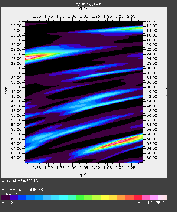
| Estimated Moho Depth: |
25.5 km |
| Estimated Crust Vp/Vs: |
1.60 |
| Assumed Crust Vp: |
6.577 km/s |
| Estimated Crust Vs: |
4.11 km/s |
| Estimated Crust Poisson's Ratio: |
0.18 |
|
| Radial Match: |
86.82113 % |
| Radial Bump: |
366 |
| Transverse Match: |
71.23597 % |
| Transverse Bump: |
400 |
| SOD ConfigId: |
21709731 |
| Insert Time: |
2020-07-13 08:53:40.350 +0000 |
| GWidth: |
2.5 |
| Max Bumps: |
400 |
| Tol: |
0.001 |
|

Signal To Noise
| Channel | StoN | STA | LTA |
| TA:E19K: :BHZ:20200615T10:49:30.625016Z | 8.671079 | 4.3720254E-7 | 5.042078E-8 |
| TA:E19K: :BHN:20200615T10:49:30.625016Z | 2.5305085 | 7.611662E-8 | 3.0079573E-8 |
| TA:E19K: :BHE:20200615T10:49:30.625016Z | 3.7284136 | 1.4837046E-7 | 3.9794532E-8 |
| Arrivals |
| Ps | 2.4 SECOND |
| PpPs | 9.8 SECOND |
| PsPs/PpSs | 12 SECOND |


