You are here: Home > Network List > US - United States National Seismic Network Stations List
> Station WMOK Wichita Mountains, Oklahoma, USA > Earthquake Result Viewer
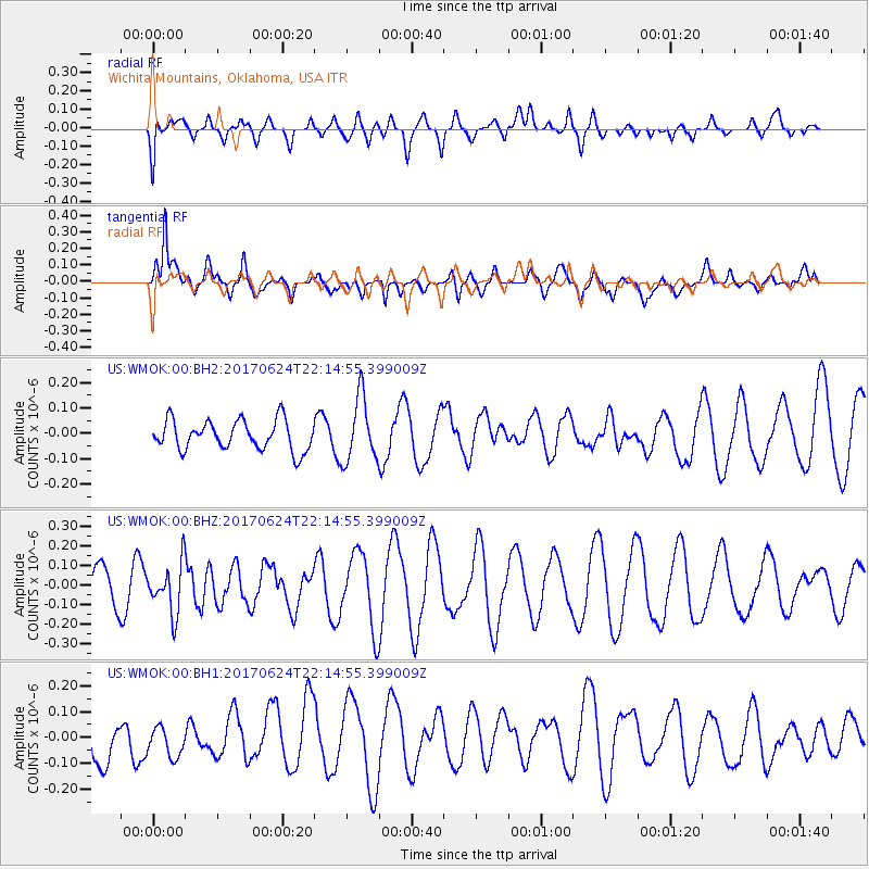
WMOK Wichita Mountains, Oklahoma, USA - Earthquake Result Viewer
*The percent match for this event was below the threshold and hence no stack was calculated.
| Earthquake location: |
Eastern Honshu, Japan |
| Earthquake latitude/longitude: |
35.8/137.6 |
| Earthquake time(UTC): |
2017/06/24 (175) 22:02:16 GMT |
| Earthquake Depth: |
10 km |
| Earthquake Magnitude: |
5.2 Mww |
| Earthquake Catalog/Contributor: |
NEIC PDE/us |
|
| Network: |
US United States National Seismic Network |
| Station: |
WMOK Wichita Mountains, Oklahoma, USA |
| Lat/Lon: |
34.74 N/98.78 W |
| Elevation: |
486 m |
|
| Distance: |
92.3 deg |
| Az: |
43.35 deg |
| Baz: |
317.356 deg |
| Ray Param: |
$rayparam |
*The percent match for this event was below the threshold and hence was not used in the summary stack. |
|
| Radial Match: |
37.2305 % |
| Radial Bump: |
400 |
| Transverse Match: |
71.24691 % |
| Transverse Bump: |
400 |
| SOD ConfigId: |
2140511 |
| Insert Time: |
2017-07-08 14:05:23.579 +0000 |
| GWidth: |
2.5 |
| Max Bumps: |
400 |
| Tol: |
0.001 |
|
Signal To Noise
| Channel | StoN | STA | LTA |
| US:WMOK:00:BHZ:20170624T22:14:55.399009Z | 1.3283429 | 1.2448643E-7 | 9.3715585E-8 |
| US:WMOK:00:BH1:20170624T22:14:55.399009Z | 1.0218656 | 6.564575E-8 | 6.424108E-8 |
| US:WMOK:00:BH2:20170624T22:14:55.399009Z | 2.1547813 | 1.2520862E-7 | 5.8107343E-8 |
| Arrivals |
| Ps | |
| PpPs | |
| PsPs/PpSs | |


