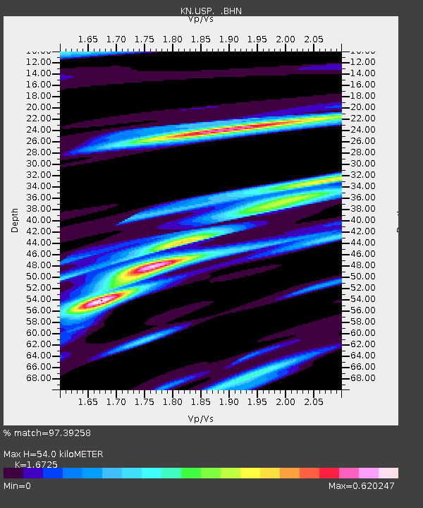
USP KN.USP - Earthquake Result Viewer

Earthquake location: Sulawesi, Indonesia
Earthquake latitude/longitude: -1.1/123.6
Earthquake time(UTC): 2000/05/04 (125) 04:21:16 GMT
Earthquake Depth: 26 km
Earthquake Magnitude: 6.7 MB, 7.5 MS, 7.6 MW, 7.5 ME
Earthquake Catalog/Contributor: WHDF/NEIC
Network: KN Kyrgyz Seismic Telemetry Network
Station: USP KN.USP
Lat/Lon: 43.27 N/74.50 E
Elevation: 740 m
Distance: 62.3 deg
Az: 321.426 deg
Baz: 121.411 deg
Ray Param: 0.060301676
Estimated Moho Depth: 54.0 km
Estimated Crust Vp/Vs: 1.67
Assumed Crust Vp: 6.306 km/s
Estimated Crust Vs: 3.77 km/s
Estimated Crust Poisson's Ratio: 0.22
Radial Match: 97.39258 %
Radial Bump: 379
Transverse Match: 84.16246 %
Transverse Bump: 400
SOD ConfigId: 3744
Insert Time: 2010-03-08 22:22:53.779 +0000
GWidth: 2.5
Max Bumps: 400
Tol: 0.001

Signal To Noise

ChannelStoNSTALTA
KN:USP: :BHN:20000504T04:31:04.874001Z45.515241.2200426E-62.6805145E-8
KN:USP: :BHE:20000504T04:31:04.874001Z31.3969462.0028076E-66.3789884E-8
KN:USP: :BHZ:20000504T04:31:04.874001Z87.772515.0237263E-65.7235763E-8
Arrivals
Ps6.0 SECOND
PpPs22 SECOND
PsPs/PpSs28 SECOND