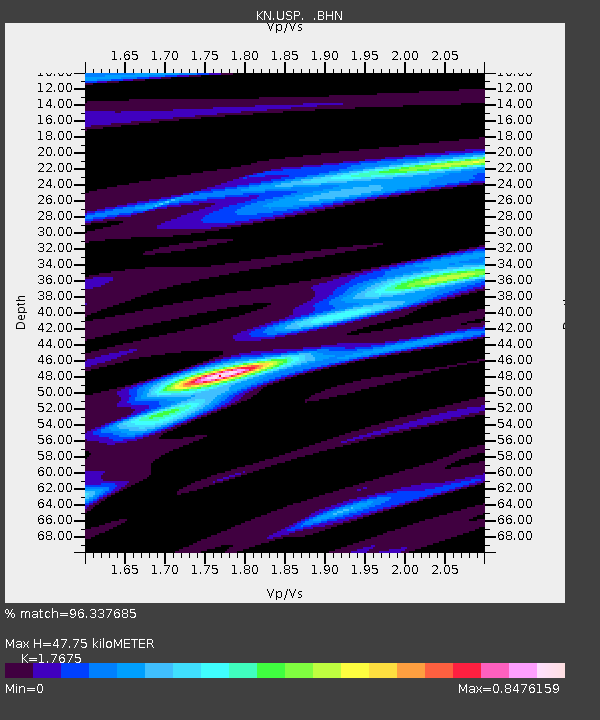
USP KN.USP - Earthquake Result Viewer
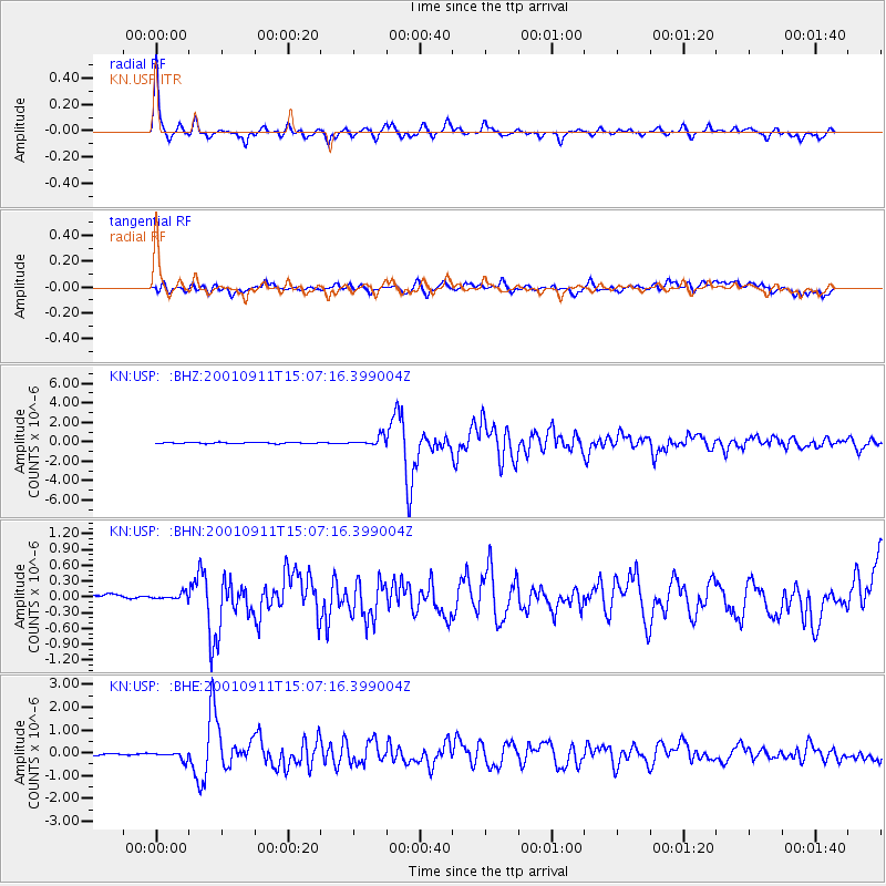
Earthquake location: Irian Jaya Region, Indonesia
Earthquake latitude/longitude: -0.6/133.1
Earthquake time(UTC): 2001/09/11 (254) 14:56:50 GMT
Earthquake Depth: 33 km
Earthquake Magnitude: 5.8 MB, 6.4 MS, 6.6 MW, 6.5 MW
Earthquake Catalog/Contributor: WHDF/NEIC
Network: KN Kyrgyz Seismic Telemetry Network
Station: USP KN.USP
Lat/Lon: 43.27 N/74.50 E
Elevation: 740 m
Distance: 68.1 deg
Az: 317.754 deg
Baz: 113.023 deg
Ray Param: 0.05649006
Estimated Moho Depth: 47.75 km
Estimated Crust Vp/Vs: 1.77
Assumed Crust Vp: 6.306 km/s
Estimated Crust Vs: 3.568 km/s
Estimated Crust Poisson's Ratio: 0.26
Radial Match: 96.337685 %
Radial Bump: 252
Transverse Match: 83.93473 %
Transverse Bump: 400
SOD ConfigId: 20082
Insert Time: 2010-03-08 22:23:41.021 +0000
GWidth: 2.5
Max Bumps: 400
Tol: 0.001

Signal To Noise

ChannelStoNSTALTA
KN:USP: :BHN:20010911T15:07:16.399004Z0.906938258.468082E-89.337E-8
KN:USP: :BHE:20010911T15:07:16.399004Z4.1119771.7211902E-74.185797E-8
KN:USP: :BHZ:20010911T15:07:16.399004Z8.0900814.6042257E-75.6911983E-8
Arrivals
Ps6.0 SECOND
PpPs20 SECOND
PsPs/PpSs26 SECOND