You are here: Home > Network List > KN - Kyrgyz Seismic Telemetry Network Stations List
> Station USP KN.USP > Earthquake Result Viewer
USP KN.USP - Earthquake Result Viewer
| Earthquake location: |
South Indian Ocean |
| Earthquake latitude/longitude: |
-13.2/97.3 |
| Earthquake time(UTC): |
2001/09/07 (250) 02:45:59 GMT |
| Earthquake Depth: |
10 km |
| Earthquake Magnitude: |
6.2 MB, 5.8 MS, 6.0 MW, 5.9 MW |
| Earthquake Catalog/Contributor: |
WHDF/NEIC |
|
| Network: |
KN Kyrgyz Seismic Telemetry Network |
| Station: |
USP KN.USP |
| Lat/Lon: |
43.27 N/74.50 E |
| Elevation: |
740 m |
|
| Distance: |
59.9 deg |
| Az: |
340.906 deg |
| Baz: |
154.138 deg |
| Ray Param: |
0.061878674 |
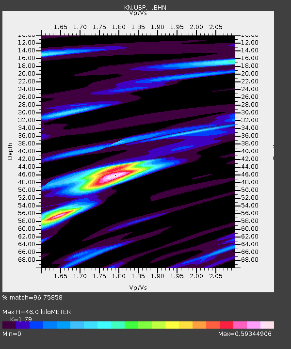
| Estimated Moho Depth: |
46.0 km |
| Estimated Crust Vp/Vs: |
1.79 |
| Assumed Crust Vp: |
6.306 km/s |
| Estimated Crust Vs: |
3.523 km/s |
| Estimated Crust Poisson's Ratio: |
0.27 |
|
| Radial Match: |
96.75858 % |
| Radial Bump: |
259 |
| Transverse Match: |
87.00255 % |
| Transverse Bump: |
400 |
| SOD ConfigId: |
20082 |
| Insert Time: |
2010-03-08 22:23:42.112 +0000 |
| GWidth: |
2.5 |
| Max Bumps: |
400 |
| Tol: |
0.001 |
|

Signal To Noise
| Channel | StoN | STA | LTA |
| KN:USP: :BHN:20010907T02:55:33.924011Z | 41.287174 | 1.4986192E-6 | 3.6297454E-8 |
| KN:USP: :BHE:20010907T02:55:33.924011Z | 13.8468075 | 6.071382E-7 | 4.38468E-8 |
| KN:USP: :BHZ:20010907T02:55:33.924011Z | 77.522804 | 3.6434622E-6 | 4.6998586E-8 |
| Arrivals |
| Ps | 6.0 SECOND |
| PpPs | 19 SECOND |
| PsPs/PpSs | 25 SECOND |


