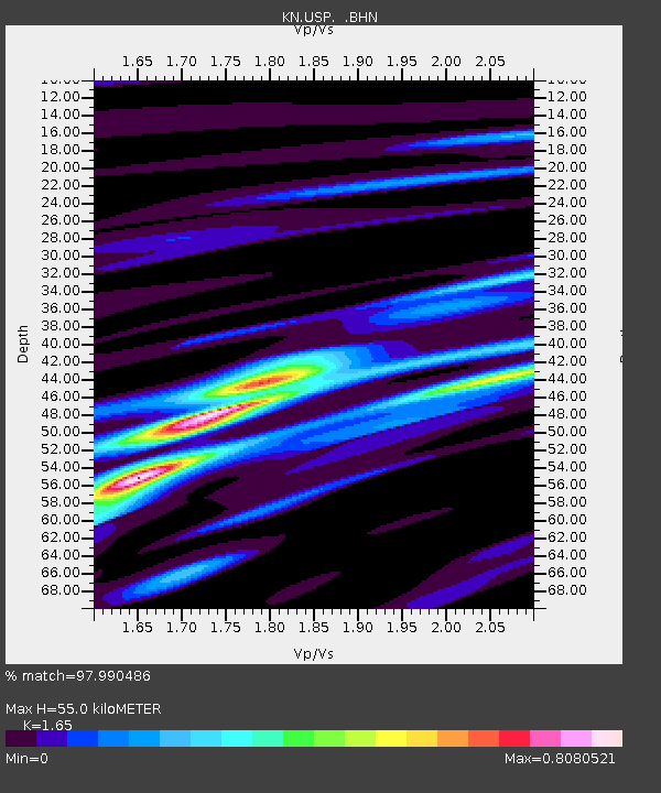
USP KN.USP - Earthquake Result Viewer
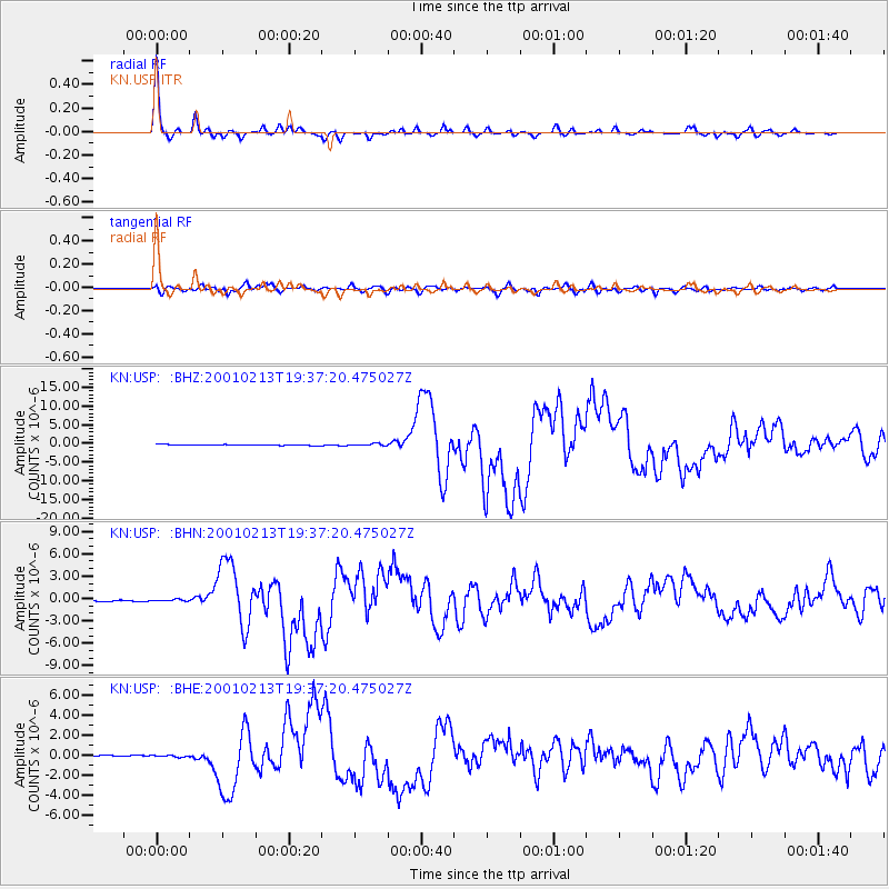
Earthquake location: Southern Sumatra, Indonesia
Earthquake latitude/longitude: -4.7/102.6
Earthquake time(UTC): 2001/02/13 (044) 19:28:30 GMT
Earthquake Depth: 36 km
Earthquake Magnitude: 6.2 MB, 7.2 MS, 7.4 MW, 7.0 ME
Earthquake Catalog/Contributor: WHDF/NEIC
Network: KN Kyrgyz Seismic Telemetry Network
Station: USP KN.USP
Lat/Lon: 43.27 N/74.50 E
Elevation: 740 m
Distance: 54.0 deg
Az: 334.881 deg
Baz: 144.604 deg
Ray Param: 0.065624855
Estimated Moho Depth: 55.0 km
Estimated Crust Vp/Vs: 1.65
Assumed Crust Vp: 6.306 km/s
Estimated Crust Vs: 3.822 km/s
Estimated Crust Poisson's Ratio: 0.21
Radial Match: 97.990486 %
Radial Bump: 264
Transverse Match: 91.227936 %
Transverse Bump: 400
SOD ConfigId: 3744
Insert Time: 2010-03-08 22:24:04.717 +0000
GWidth: 2.5
Max Bumps: 400
Tol: 0.001

Signal To Noise

ChannelStoNSTALTA
KN:USP: :BHN:20010213T19:37:20.475027Z1.24506871.1982527E-79.6239894E-8
KN:USP: :BHE:20010213T19:37:20.475027Z1.44184928.182325E-85.6748828E-8
KN:USP: :BHZ:20010213T19:37:20.475027Z2.6801862.9321714E-71.0940179E-7
Arrivals
Ps6.0 SECOND
PpPs22 SECOND
PsPs/PpSs28 SECOND