You are here: Home > Network List > PE - Penn State Network Stations List
> Station PSUB Bremner River > Earthquake Result Viewer
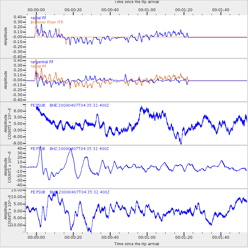
PSUB Bremner River - Earthquake Result Viewer
*The percent match for this event was below the threshold and hence no stack was calculated.
| Earthquake location: |
Kuril Islands |
| Earthquake latitude/longitude: |
46.0/151.5 |
| Earthquake time(UTC): |
2009/04/07 (097) 04:23:33 GMT |
| Earthquake Depth: |
31 km |
| Earthquake Magnitude: |
6.5 MB, 6.8 MS, 6.9 MW, 6.9 MW |
| Earthquake Catalog/Contributor: |
WHDF/NEIC |
|
| Network: |
PE Penn State Network |
| Station: |
PSUB Bremner River |
| Lat/Lon: |
39.93 N/75.45 W |
| Elevation: |
303 m |
|
| Distance: |
84.6 deg |
| Az: |
34.39 deg |
| Baz: |
329.231 deg |
| Ray Param: |
$rayparam |
*The percent match for this event was below the threshold and hence was not used in the summary stack. |
|
| Radial Match: |
56.154617 % |
| Radial Bump: |
400 |
| Transverse Match: |
78.9777 % |
| Transverse Bump: |
400 |
| SOD ConfigId: |
2658 |
| Insert Time: |
2010-02-26 14:56:17.566 +0000 |
| GWidth: |
2.5 |
| Max Bumps: |
400 |
| Tol: |
0.001 |
|
Signal To Noise
| Channel | StoN | STA | LTA |
| PE:PSUB: :BHZ:20090407T04:35:32.400Z | 21.564037 | 2.041027E-5 | 9.464958E-7 |
| PE:PSUB: :BHN:20090407T04:35:32.400Z | 1.1397011 | 4.3495206E-6 | 3.8163694E-6 |
| PE:PSUB: :BHE:20090407T04:35:32.400Z | 0.6911096 | 1.8766965E-6 | 2.715483E-6 |
| Arrivals |
| Ps | |
| PpPs | |
| PsPs/PpSs | |


