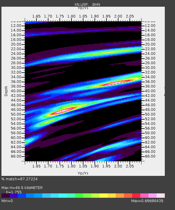
USP KN.USP - Earthquake Result Viewer

Earthquake location: Northern Molucca Sea
Earthquake latitude/longitude: 1.3/126.2
Earthquake time(UTC): 2001/02/24 (055) 07:23:48 GMT
Earthquake Depth: 35 km
Earthquake Magnitude: 6.6 MB, 7.0 MS, 7.1 MW, 7.1 ME
Earthquake Catalog/Contributor: WHDF/NEIC
Network: KN Kyrgyz Seismic Telemetry Network
Station: USP KN.USP
Lat/Lon: 43.27 N/74.50 E
Elevation: 740 m
Distance: 62.1 deg
Az: 319.55 deg
Baz: 117.38 deg
Ray Param: 0.060356557
Estimated Moho Depth: 48.5 km
Estimated Crust Vp/Vs: 1.75
Assumed Crust Vp: 6.306 km/s
Estimated Crust Vs: 3.593 km/s
Estimated Crust Poisson's Ratio: 0.26
Radial Match: 97.27224 %
Radial Bump: 294
Transverse Match: 87.55833 %
Transverse Bump: 400
SOD ConfigId: 3744
Insert Time: 2010-03-08 22:24:06.075 +0000
GWidth: 2.5
Max Bumps: 400
Tol: 0.001

Signal To Noise

ChannelStoNSTALTA
KN:USP: :BHN:20010224T07:33:35.62502Z27.5020891.1394638E-64.1431903E-8
KN:USP: :BHE:20010224T07:33:35.62502Z54.3276672.6116786E-64.8072717E-8
KN:USP: :BHZ:20010224T07:33:35.62502Z98.438756.103297E-66.200096E-8
Arrivals
Ps6.1 SECOND
PpPs20 SECOND
PsPs/PpSs26 SECOND