You are here: Home > Network List > TX - Texas Seismological Network Stations List
> Station WTFS Witchita Falls > Earthquake Result Viewer
WTFS Witchita Falls - Earthquake Result Viewer
*The percent match for this event was below the threshold and hence no stack was calculated.
| Earthquake location: |
Ascension Island Region |
| Earthquake latitude/longitude: |
-11.7/-13.4 |
| Earthquake time(UTC): |
2020/06/29 (181) 19:40:13 GMT |
| Earthquake Depth: |
10 km |
| Earthquake Magnitude: |
5.6 Mww |
| Earthquake Catalog/Contributor: |
NEIC PDE/us |
|
| Network: |
TX Texas Seismological Network |
| Station: |
WTFS Witchita Falls |
| Lat/Lon: |
33.77 N/98.46 W |
| Elevation: |
277 m |
|
| Distance: |
92.3 deg |
| Az: |
303.841 deg |
| Baz: |
102.368 deg |
| Ray Param: |
$rayparam |
*The percent match for this event was below the threshold and hence was not used in the summary stack. |
|
| Radial Match: |
43.080597 % |
| Radial Bump: |
400 |
| Transverse Match: |
50.602646 % |
| Transverse Bump: |
386 |
| SOD ConfigId: |
21709731 |
| Insert Time: |
2020-07-13 19:52:02.440 +0000 |
| GWidth: |
2.5 |
| Max Bumps: |
400 |
| Tol: |
0.001 |
|
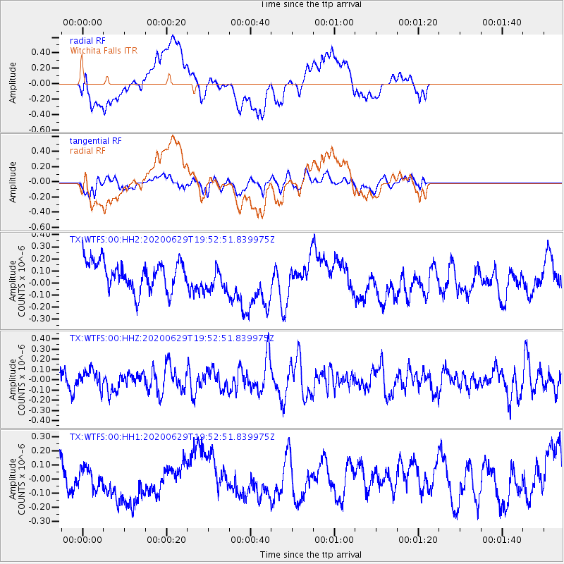
Signal To Noise
| Channel | StoN | STA | LTA |
| TX:WTFS:00:HHZ:20200629T19:52:51.839975Z | 0.7290953 | 8.9588994E-8 | 1.2287694E-7 |
| TX:WTFS:00:HH1:20200629T19:52:51.839975Z | 0.8493215 | 7.38155E-8 | 8.691114E-8 |
| TX:WTFS:00:HH2:20200629T19:52:51.839975Z | 0.93670803 | 1.09776266E-7 | 1.17193686E-7 |
| Arrivals |
| Ps | |
| PpPs | |
| PsPs/PpSs | |


