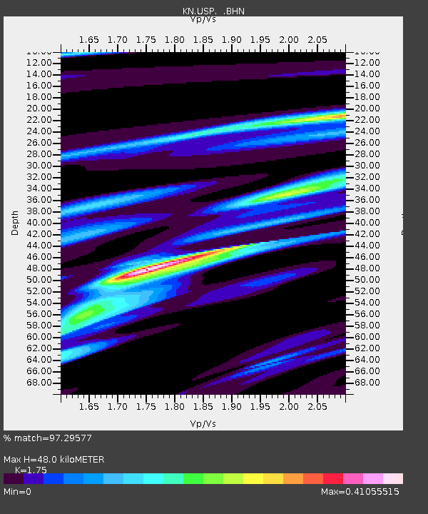
USP KN.USP - Earthquake Result Viewer

Earthquake location: New Britain Region, P.N.G.
Earthquake latitude/longitude: -5.2/150.9
Earthquake time(UTC): 1999/05/10 (130) 20:33:02 GMT
Earthquake Depth: 138 km
Earthquake Magnitude: 6.5 MB, 6.8 MS, 7.1 MW, 6.5 MB
Earthquake Catalog/Contributor: WHDF/NEIC
Network: KN Kyrgyz Seismic Telemetry Network
Station: USP KN.USP
Lat/Lon: 43.27 N/74.50 E
Elevation: 740 m
Distance: 83.7 deg
Az: 314.416 deg
Baz: 103.109 deg
Ray Param: 0.04571156
Estimated Moho Depth: 48.0 km
Estimated Crust Vp/Vs: 1.75
Assumed Crust Vp: 6.306 km/s
Estimated Crust Vs: 3.603 km/s
Estimated Crust Poisson's Ratio: 0.26
Radial Match: 97.29577 %
Radial Bump: 284
Transverse Match: 90.930275 %
Transverse Bump: 400
SOD ConfigId: 4480
Insert Time: 2010-03-08 22:25:01.484 +0000
GWidth: 2.5
Max Bumps: 400
Tol: 0.001

Signal To Noise

ChannelStoNSTALTA
KN:USP: :BHN:19990510T20:44:44.149021Z16.2935541.204571E-67.39293E-8
KN:USP: :BHE:19990510T20:44:44.149021Z1.38291676.544113E-84.732109E-8
KN:USP: :BHZ:19990510T20:44:44.149021Z8.0051023.8860546E-74.8544724E-8
Arrivals
Ps5.8 SECOND
PpPs20 SECOND
PsPs/PpSs26 SECOND