You are here: Home > Network List > KN - Kyrgyz Seismic Telemetry Network Stations List
> Station USP KN.USP > Earthquake Result Viewer
USP KN.USP - Earthquake Result Viewer
| Earthquake location: |
Hokkaido, Japan Region |
| Earthquake latitude/longitude: |
43.0/143.8 |
| Earthquake time(UTC): |
1999/05/12 (132) 17:59:22 GMT |
| Earthquake Depth: |
103 km |
| Earthquake Magnitude: |
5.9 MB, 6.2 MW, 6.1 MW |
| Earthquake Catalog/Contributor: |
WHDF/NEIC |
|
| Network: |
KN Kyrgyz Seismic Telemetry Network |
| Station: |
USP KN.USP |
| Lat/Lon: |
43.27 N/74.50 E |
| Elevation: |
740 m |
|
| Distance: |
49.2 deg |
| Az: |
295.466 deg |
| Baz: |
64.998 deg |
| Ray Param: |
0.0685199 |
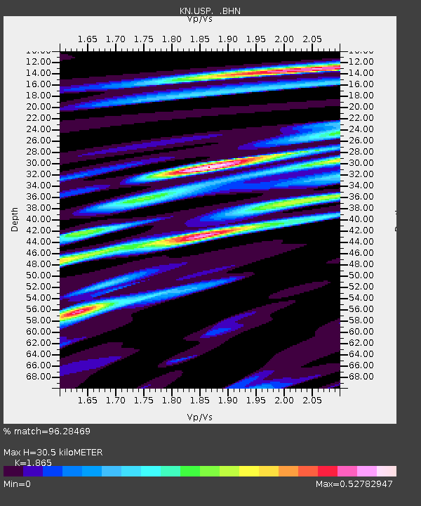
| Estimated Moho Depth: |
30.5 km |
| Estimated Crust Vp/Vs: |
1.87 |
| Assumed Crust Vp: |
6.306 km/s |
| Estimated Crust Vs: |
3.381 km/s |
| Estimated Crust Poisson's Ratio: |
0.30 |
|
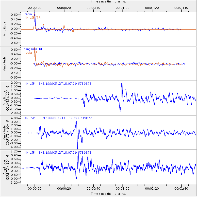
| Radial Match: |
96.28469 % |
| Radial Bump: |
310 |
| Transverse Match: |
79.50426 % |
| Transverse Bump: |
400 |
| SOD ConfigId: |
4480 |
| Insert Time: |
2010-03-08 22:25:02.763 +0000 |
| GWidth: |
2.5 |
| Max Bumps: |
400 |
| Tol: |
0.001 |
|
Signal To Noise
| Channel | StoN | STA | LTA |
| KN:USP: :BHN:19990512T18:07:29.673987Z | 19.007433 | 7.343439E-7 | 3.8634568E-8 |
| KN:USP: :BHE:19990512T18:07:29.673987Z | 6.113991 | 1.8472898E-7 | 3.021414E-8 |
| KN:USP: :BHZ:19990512T18:07:29.673987Z | 10.005915 | 3.6532626E-7 | 3.651103E-8 |
| Arrivals |
| Ps | 4.4 SECOND |
| PpPs | 13 SECOND |
| PsPs/PpSs | 18 SECOND |


