You are here: Home > Network List > KN - Kyrgyz Seismic Telemetry Network Stations List
> Station USP KN.USP > Earthquake Result Viewer
USP KN.USP - Earthquake Result Viewer

| Earthquake location: |
Mindanao, Philippines |
| Earthquake latitude/longitude: |
6.0/124.2 |
| Earthquake time(UTC): |
2002/03/05 (064) 21:16:09 GMT |
| Earthquake Depth: |
31 km |
| Earthquake Magnitude: |
6.3 MB, 7.2 MS, 7.5 MW, 7.2 MW |
| Earthquake Catalog/Contributor: |
WHDF/NEIC |
|
| Network: |
KN Kyrgyz Seismic Telemetry Network |
| Station: |
USP KN.USP |
| Lat/Lon: |
43.27 N/74.50 E |
| Elevation: |
740 m |
|
| Distance: |
57.3 deg |
| Az: |
318.491 deg |
| Baz: |
115.534 deg |
| Ray Param: |
0.06354691 |
| Estimated Moho Depth: |
47.0 km |
| Estimated Crust Vp/Vs: |
1.78 |
| Assumed Crust Vp: |
6.306 km/s |
| Estimated Crust Vs: |
3.543 km/s |
| Estimated Crust Poisson's Ratio: |
0.27 |
|
| Radial Match: |
95.54084 % |
| Radial Bump: |
291 |
| Transverse Match: |
84.818405 % |
| Transverse Bump: |
400 |
| SOD ConfigId: |
20082 |
| Insert Time: |
2010-03-08 22:25:38.492 +0000 |
| GWidth: |
2.5 |
| Max Bumps: |
400 |
| Tol: |
0.001 |
|
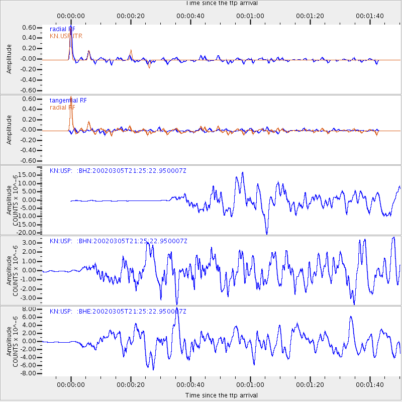
Signal To Noise
| Channel | StoN | STA | LTA |
| KN:USP: :BHN:20020305T21:25:22.950007Z | 2.4559262 | 2.2326891E-7 | 9.091027E-8 |
| KN:USP: :BHE:20020305T21:25:22.950007Z | 8.372833 | 5.7168177E-7 | 6.8278176E-8 |
| KN:USP: :BHZ:20020305T21:25:22.950007Z | 6.429804 | 1.0239208E-6 | 1.5924604E-7 |
| Arrivals |
| Ps | 6.1 SECOND |
| PpPs | 20 SECOND |
| PsPs/PpSs | 26 SECOND |


