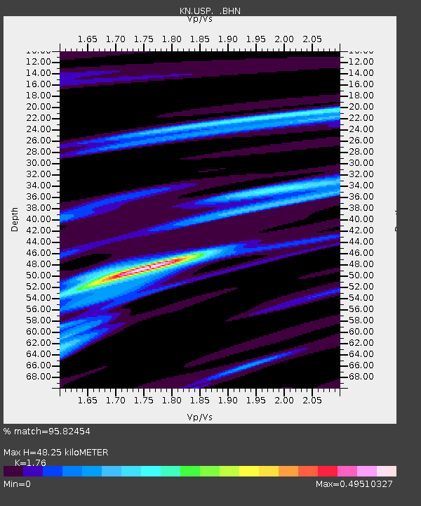
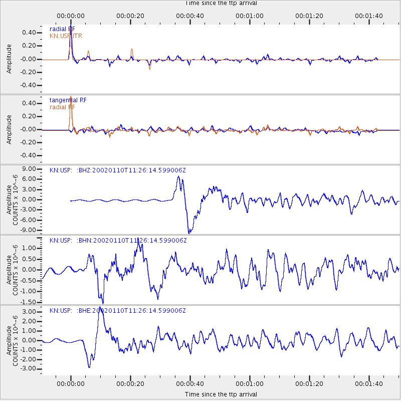
USP KN.USP - Earthquake Result Viewer

Earthquake location: Near N Coast Of New Guinea, P.N.G.
Earthquake latitude/longitude: -3.2/142.4
Earthquake time(UTC): 2002/01/10 (010) 11:14:56 GMT
Earthquake Depth: 11 km
Earthquake Magnitude: 6.0 MB, 6.6 MS, 6.7 MW, 6.6 MW
Earthquake Catalog/Contributor: WHDF/NEIC
Network: KN Kyrgyz Seismic Telemetry Network
Station: USP KN.USP
Lat/Lon: 43.27 N/74.50 E
Elevation: 740 m
Distance: 76.3 deg
Az: 315.844 deg
Baz: 107.79 deg
Ray Param: 0.0510542
Estimated Moho Depth: 48.25 km
Estimated Crust Vp/Vs: 1.76
Assumed Crust Vp: 6.306 km/s
Estimated Crust Vs: 3.583 km/s
Estimated Crust Poisson's Ratio: 0.26
Radial Match: 95.82454 %
Radial Bump: 280
Transverse Match: 82.49101 %
Transverse Bump: 400
SOD ConfigId: 20082
Insert Time: 2010-03-08 22:25:39.754 +0000
GWidth: 2.5
Max Bumps: 400
Tol: 0.001

Signal To Noise

ChannelStoNSTALTA
KN:USP: :BHN:20020110T11:26:14.599006Z0.479731681.1488729E-72.394824E-7
KN:USP: :BHE:20020110T11:26:14.599006Z2.215562.1898894E-79.884135E-8
KN:USP: :BHZ:20020110T11:26:14.599006Z3.52842786.385015E-71.8095919E-7
Arrivals
Ps6.0 SECOND
PpPs20 SECOND
PsPs/PpSs26 SECOND