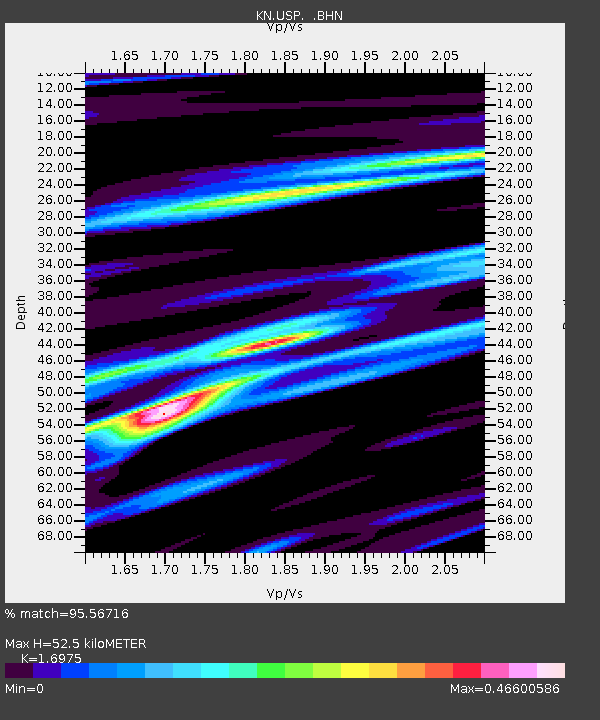
USP KN.USP - Earthquake Result Viewer

Earthquake location: Sumbawa Region, Indonesia
Earthquake latitude/longitude: -8.2/118.3
Earthquake time(UTC): 2002/10/06 (279) 15:46:33 GMT
Earthquake Depth: 10 km
Earthquake Magnitude: 5.8 MB, 6.0 MS, 6.2 MW, 6.2 MW
Earthquake Catalog/Contributor: WHDF/NEIC
Network: KN Kyrgyz Seismic Telemetry Network
Station: USP KN.USP
Lat/Lon: 43.27 N/74.50 E
Elevation: 740 m
Distance: 64.9 deg
Az: 326.02 deg
Baz: 130.763 deg
Ray Param: 0.058650475
Estimated Moho Depth: 52.5 km
Estimated Crust Vp/Vs: 1.70
Assumed Crust Vp: 6.306 km/s
Estimated Crust Vs: 3.715 km/s
Estimated Crust Poisson's Ratio: 0.23
Radial Match: 95.56716 %
Radial Bump: 303
Transverse Match: 81.61122 %
Transverse Bump: 400
SOD ConfigId: 4714
Insert Time: 2010-03-08 22:26:12.126 +0000
GWidth: 2.5
Max Bumps: 400
Tol: 0.001

Signal To Noise

ChannelStoNSTALTA
KN:USP: :BHN:20021006T15:56:41.025015Z1.95613655.5160463E-82.8198679E-8
KN:USP: :BHE:20021006T15:56:41.025015Z1.44838825.027013E-83.4707636E-8
KN:USP: :BHZ:20021006T15:56:41.025015Z4.32253271.8844548E-74.359608E-8
Arrivals
Ps6.1 SECOND
PpPs22 SECOND
PsPs/PpSs28 SECOND