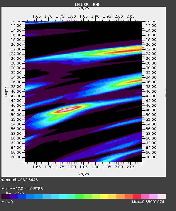
USP KN.USP - Earthquake Result Viewer
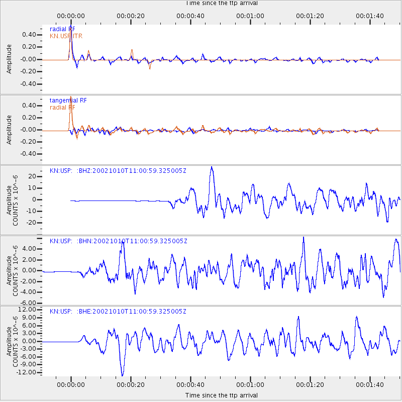
Earthquake location: Irian Jaya Region, Indonesia
Earthquake latitude/longitude: -1.8/134.3
Earthquake time(UTC): 2002/10/10 (283) 10:50:20 GMT
Earthquake Depth: 10 km
Earthquake Magnitude: 6.5 MB, 7.7 MS, 7.6 MW, 7.4 MW
Earthquake Catalog/Contributor: WHDF/NEIC
Network: KN Kyrgyz Seismic Telemetry Network
Station: USP KN.USP
Lat/Lon: 43.27 N/74.50 E
Elevation: 740 m
Distance: 69.7 deg
Az: 317.701 deg
Baz: 112.942 deg
Ray Param: 0.055455174
Estimated Moho Depth: 47.5 km
Estimated Crust Vp/Vs: 1.78
Assumed Crust Vp: 6.306 km/s
Estimated Crust Vs: 3.548 km/s
Estimated Crust Poisson's Ratio: 0.27
Radial Match: 96.16446 %
Radial Bump: 261
Transverse Match: 81.820145 %
Transverse Bump: 400
SOD ConfigId: 4714
Insert Time: 2010-03-08 22:26:13.868 +0000
GWidth: 2.5
Max Bumps: 400
Tol: 0.001

Signal To Noise

ChannelStoNSTALTA
KN:USP: :BHN:20021010T11:00:59.325005Z5.0911334.052813E-77.960533E-8
KN:USP: :BHE:20021010T11:00:59.325005Z20.3840141.0270854E-65.0386813E-8
KN:USP: :BHZ:20021010T11:00:59.325005Z29.4526522.4562721E-68.339732E-8
Arrivals
Ps6.1 SECOND
PpPs20 SECOND
PsPs/PpSs26 SECOND