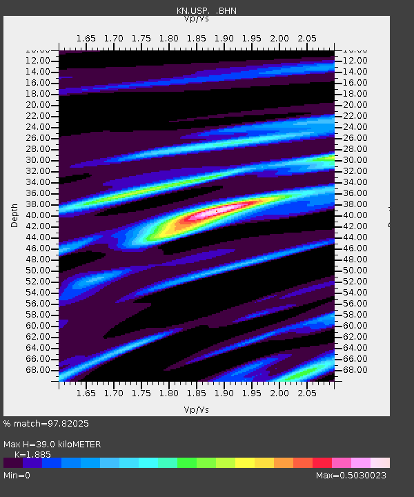
USP KN.USP - Earthquake Result Viewer
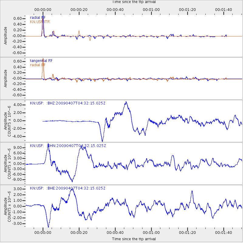
Earthquake location: Kuril Islands
Earthquake latitude/longitude: 46.0/151.5
Earthquake time(UTC): 2009/04/07 (097) 04:23:33 GMT
Earthquake Depth: 31 km
Earthquake Magnitude: 6.5 MB, 6.8 MS, 6.9 MW, 6.9 MW
Earthquake Catalog/Contributor: WHDF/NEIC
Network: KN Kyrgyz Seismic Telemetry Network
Station: USP KN.USP
Lat/Lon: 43.27 N/74.50 E
Elevation: 740 m
Distance: 52.8 deg
Az: 296.708 deg
Baz: 58.399 deg
Ray Param: 0.066446856
Estimated Moho Depth: 39.0 km
Estimated Crust Vp/Vs: 1.88
Assumed Crust Vp: 6.306 km/s
Estimated Crust Vs: 3.345 km/s
Estimated Crust Poisson's Ratio: 0.30
Radial Match: 97.82025 %
Radial Bump: 307
Transverse Match: 87.181885 %
Transverse Bump: 400
SOD ConfigId: 2658
Insert Time: 2010-03-08 22:26:23.409 +0000
GWidth: 2.5
Max Bumps: 400
Tol: 0.001

Signal To Noise

ChannelStoNSTALTA
KN:USP: :BHN:20090407T04:32:15.025Z92.051765.257441E-65.711396E-8
KN:USP: :BHE:20090407T04:32:15.025Z6.8591231.6872127E-62.459808E-7
KN:USP: :BHZ:20090407T04:32:15.025Z31.7410852.5057443E-67.8943245E-8
Arrivals
Ps5.8 SECOND
PpPs17 SECOND
PsPs/PpSs23 SECOND