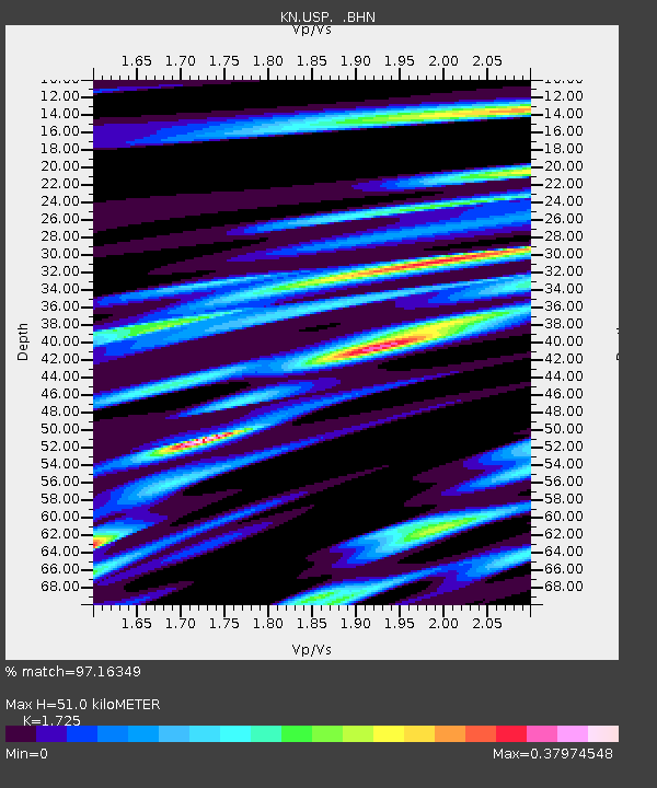
USP KN.USP - Earthquake Result Viewer

Earthquake location: Rat Islands, Aleutian Islands
Earthquake latitude/longitude: 51.6/176.9
Earthquake time(UTC): 2003/06/15 (166) 19:24:33 GMT
Earthquake Depth: 20 km
Earthquake Magnitude: 6.0 MB, 6.4 MS, 6.5 MW, 6.5 MW
Earthquake Catalog/Contributor: WHDF/NEIC
Network: KN Kyrgyz Seismic Telemetry Network
Station: USP KN.USP
Lat/Lon: 43.27 N/74.50 E
Elevation: 740 m
Distance: 64.2 deg
Az: 307.59 deg
Baz: 42.633 deg
Ray Param: 0.05905926
Estimated Moho Depth: 51.0 km
Estimated Crust Vp/Vs: 1.73
Assumed Crust Vp: 6.306 km/s
Estimated Crust Vs: 3.656 km/s
Estimated Crust Poisson's Ratio: 0.25
Radial Match: 97.16349 %
Radial Bump: 375
Transverse Match: 90.66445 %
Transverse Bump: 400
SOD ConfigId: 4714
Insert Time: 2010-03-08 22:26:26.724 +0000
GWidth: 2.5
Max Bumps: 400
Tol: 0.001

Signal To Noise

ChannelStoNSTALTA
KN:USP: :BHN:20030615T19:34:35.300024Z30.7291988.792196E-72.8611863E-8
KN:USP: :BHE:20030615T19:34:35.300024Z26.7332557.784574E-72.9119438E-8
KN:USP: :BHZ:20030615T19:34:35.300024Z48.9772342.6356922E-65.381464E-8
Arrivals
Ps6.1 SECOND
PpPs21 SECOND
PsPs/PpSs27 SECOND