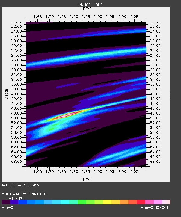
USP KN.USP - Earthquake Result Viewer

Earthquake location: Solomon Islands
Earthquake latitude/longitude: -10.5/160.8
Earthquake time(UTC): 2003/01/20 (020) 08:43:06 GMT
Earthquake Depth: 33 km
Earthquake Magnitude: 6.7 MB, 7.8 MS, 7.3 MW, 7.2 MW
Earthquake Catalog/Contributor: WHDF/NEIC
Network: KN Kyrgyz Seismic Telemetry Network
Station: USP KN.USP
Lat/Lon: 43.27 N/74.50 E
Elevation: 740 m
Distance: 94.4 deg
Az: 313.023 deg
Baz: 100.158 deg
Ray Param: 0.041038267
Estimated Moho Depth: 48.75 km
Estimated Crust Vp/Vs: 1.76
Assumed Crust Vp: 6.306 km/s
Estimated Crust Vs: 3.578 km/s
Estimated Crust Poisson's Ratio: 0.26
Radial Match: 96.99665 %
Radial Bump: 358
Transverse Match: 91.907845 %
Transverse Bump: 400
SOD ConfigId: 4714
Insert Time: 2010-03-08 22:26:42.798 +0000
GWidth: 2.5
Max Bumps: 400
Tol: 0.001

Signal To Noise

ChannelStoNSTALTA
KN:USP: :BHN:20030120T08:55:51.200005Z1.78173412.867482E-71.6093772E-7
KN:USP: :BHE:20030120T08:55:51.200005Z7.31122739.639251E-71.3184176E-7
KN:USP: :BHZ:20030120T08:55:51.200005Z32.5665473.3656643E-61.0334729E-7
Arrivals
Ps6.0 SECOND
PpPs21 SECOND
PsPs/PpSs27 SECOND