You are here: Home > Network List > IM - International Miscellaneous Stations Stations List
> Station MK31 Makanchi Array Site 31, Kazakhstan > Earthquake Result Viewer
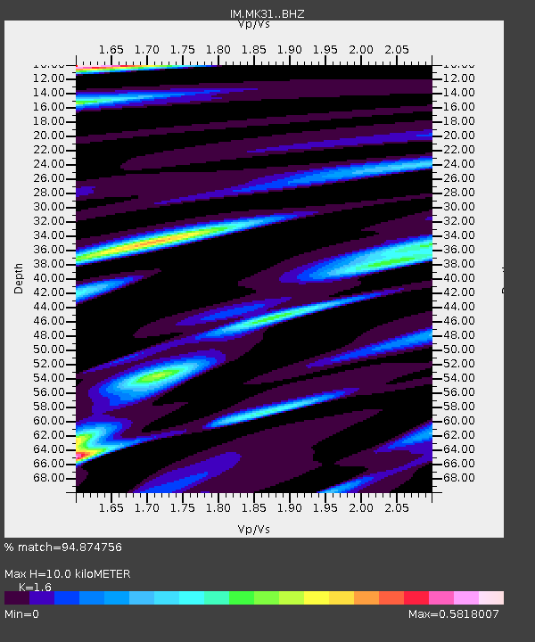
MK31 Makanchi Array Site 31, Kazakhstan - Earthquake Result Viewer
| Earthquake location: |
D'Entrecasteaux Islands Region |
| Earthquake latitude/longitude: |
-9.6/155.0 |
| Earthquake time(UTC): |
2020/07/04 (186) 01:34:44 GMT |
| Earthquake Depth: |
10 km |
| Earthquake Magnitude: |
5.6 Mww |
| Earthquake Catalog/Contributor: |
NEIC PDE/us |
|
| Network: |
IM International Miscellaneous Stations |
| Station: |
MK31 Makanchi Array Site 31, Kazakhstan |
| Lat/Lon: |
46.79 N/82.29 E |
| Elevation: |
618 m |
|
| Distance: |
85.4 deg |
| Az: |
318.844 deg |
| Baz: |
109.177 deg |
| Ray Param: |
0.044811454 |
| Estimated Moho Depth: |
10.0 km |
| Estimated Crust Vp/Vs: |
1.60 |
| Assumed Crust Vp: |
6.688 km/s |
| Estimated Crust Vs: |
4.18 km/s |
| Estimated Crust Poisson's Ratio: |
0.18 |
|
| Radial Match: |
94.874756 % |
| Radial Bump: |
290 |
| Transverse Match: |
83.67828 % |
| Transverse Bump: |
400 |
| SOD ConfigId: |
21709731 |
| Insert Time: |
2020-07-18 01:43:17.567 +0000 |
| GWidth: |
2.5 |
| Max Bumps: |
400 |
| Tol: |
0.001 |
|

Signal To Noise
| Channel | StoN | STA | LTA |
| IM:MK31: :BHZ:20200704T01:46:50.474027Z | 7.472115 | 2.0017831E-8 | 2.6790046E-9 |
| IM:MK31: :BHN:20200704T01:46:50.474027Z | 1.7459265 | 2.0729065E-9 | 1.1872817E-9 |
| IM:MK31: :BHE:20200704T01:46:50.474027Z | 4.6505914 | 5.695059E-9 | 1.2245882E-9 |
| Arrivals |
| Ps | 0.9 SECOND |
| PpPs | 3.8 SECOND |
| PsPs/PpSs | 4.7 SECOND |


