You are here: Home > Network List > TA - USArray Transportable Network (new EarthScope stations) Stations List
> Station R31K City Hall, Gustavus, AK, USA > Earthquake Result Viewer
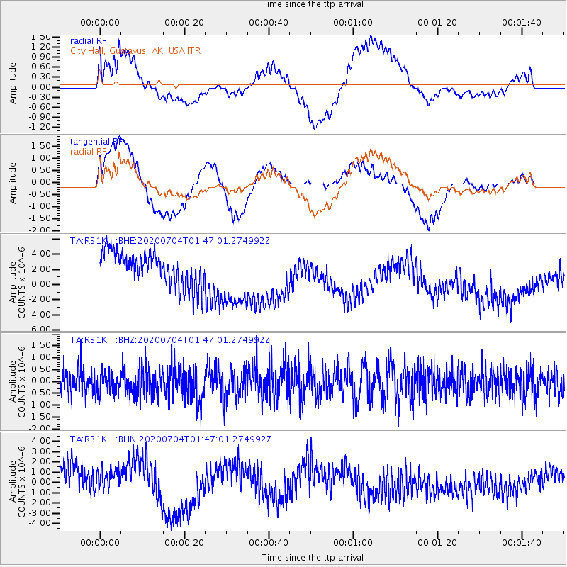
R31K City Hall, Gustavus, AK, USA - Earthquake Result Viewer
*The percent match for this event was below the threshold and hence no stack was calculated.
| Earthquake location: |
D'Entrecasteaux Islands Region |
| Earthquake latitude/longitude: |
-9.6/155.0 |
| Earthquake time(UTC): |
2020/07/04 (186) 01:34:44 GMT |
| Earthquake Depth: |
10 km |
| Earthquake Magnitude: |
5.6 Mww |
| Earthquake Catalog/Contributor: |
NEIC PDE/us |
|
| Network: |
TA USArray Transportable Network (new EarthScope stations) |
| Station: |
R31K City Hall, Gustavus, AK, USA |
| Lat/Lon: |
58.41 N/135.74 W |
| Elevation: |
15 m |
|
| Distance: |
87.6 deg |
| Az: |
29.52 deg |
| Baz: |
247.381 deg |
| Ray Param: |
$rayparam |
*The percent match for this event was below the threshold and hence was not used in the summary stack. |
|
| Radial Match: |
36.871986 % |
| Radial Bump: |
400 |
| Transverse Match: |
43.52075 % |
| Transverse Bump: |
400 |
| SOD ConfigId: |
21709731 |
| Insert Time: |
2020-07-18 01:47:39.810 +0000 |
| GWidth: |
2.5 |
| Max Bumps: |
400 |
| Tol: |
0.001 |
|
Signal To Noise
| Channel | StoN | STA | LTA |
| TA:R31K: :BHZ:20200704T01:47:01.274992Z | 0.5243524 | 3.986442E-7 | 7.6026015E-7 |
| TA:R31K: :BHN:20200704T01:47:01.274992Z | 0.8816869 | 1.7602971E-6 | 1.9965105E-6 |
| TA:R31K: :BHE:20200704T01:47:01.274992Z | 2.023441 | 4.3435734E-6 | 2.1466271E-6 |
| Arrivals |
| Ps | |
| PpPs | |
| PsPs/PpSs | |


