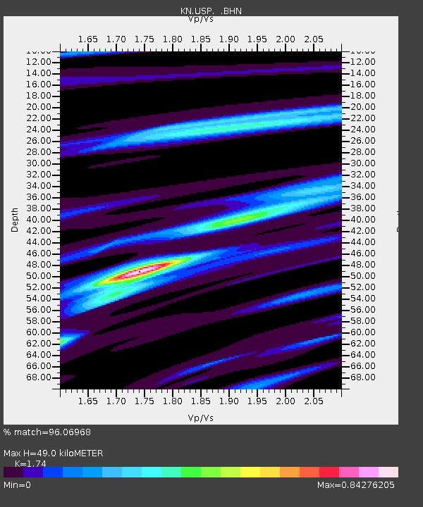
USP KN.USP - Earthquake Result Viewer
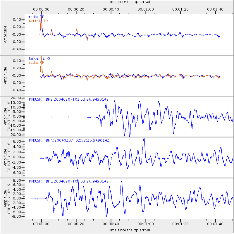
Earthquake location: Irian Jaya Region, Indonesia
Earthquake latitude/longitude: -4.0/135.0
Earthquake time(UTC): 2004/02/07 (038) 02:42:35 GMT
Earthquake Depth: 10 km
Earthquake Magnitude: 6.2 MB, 7.5 MS, 7.3 MW, 7.3 MW
Earthquake Catalog/Contributor: WHDF/NEIC
Network: KN Kyrgyz Seismic Telemetry Network
Station: USP KN.USP
Lat/Lon: 43.27 N/74.50 E
Elevation: 740 m
Distance: 71.9 deg
Az: 317.999 deg
Baz: 113.958 deg
Ray Param: 0.054041166
Estimated Moho Depth: 49.0 km
Estimated Crust Vp/Vs: 1.74
Assumed Crust Vp: 6.306 km/s
Estimated Crust Vs: 3.624 km/s
Estimated Crust Poisson's Ratio: 0.25
Radial Match: 96.06968 %
Radial Bump: 273
Transverse Match: 84.83129 %
Transverse Bump: 400
SOD ConfigId: 2459
Insert Time: 2010-03-08 22:27:44.118 +0000
GWidth: 2.5
Max Bumps: 400
Tol: 0.001

Signal To Noise

ChannelStoNSTALTA
KN:USP: :BHN:20040207T02:53:26.949014Z6.12981274.1609042E-76.7879796E-8
KN:USP: :BHE:20040207T02:53:26.949014Z10.529429.391064E-78.918881E-8
KN:USP: :BHZ:20040207T02:53:26.949014Z23.4366362.6098699E-61.1135856E-7
Arrivals
Ps6.0 SECOND
PpPs21 SECOND
PsPs/PpSs27 SECOND