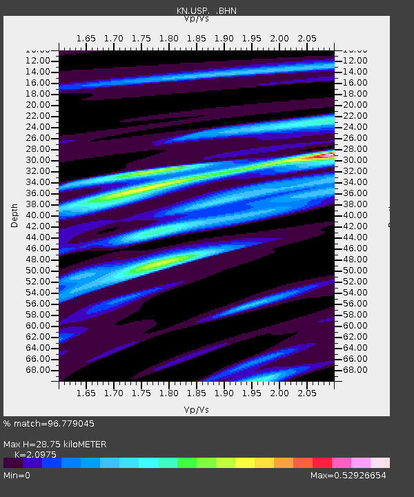
USP KN.USP - Earthquake Result Viewer
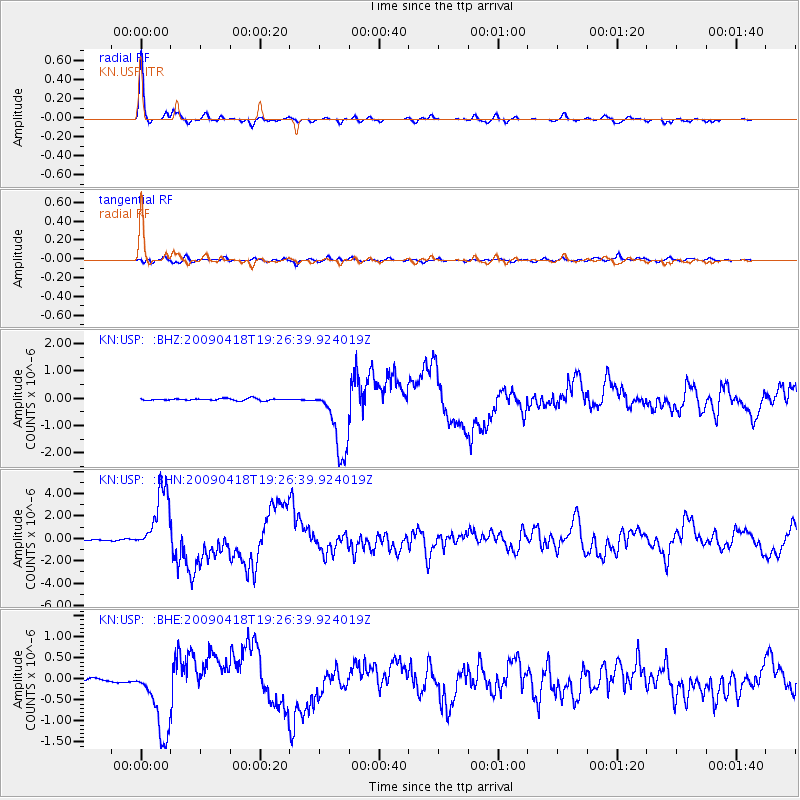
Earthquake location: Kuril Islands
Earthquake latitude/longitude: 46.0/151.4
Earthquake time(UTC): 2009/04/18 (108) 19:17:58 GMT
Earthquake Depth: 35 km
Earthquake Magnitude: 6.3 MB, 6.3 MS, 6.6 MW, 6.4 MW
Earthquake Catalog/Contributor: WHDF/NEIC
Network: KN Kyrgyz Seismic Telemetry Network
Station: USP KN.USP
Lat/Lon: 43.27 N/74.50 E
Elevation: 740 m
Distance: 52.8 deg
Az: 296.673 deg
Baz: 58.485 deg
Ray Param: 0.06647539
Estimated Moho Depth: 28.75 km
Estimated Crust Vp/Vs: 2.10
Assumed Crust Vp: 6.306 km/s
Estimated Crust Vs: 3.006 km/s
Estimated Crust Poisson's Ratio: 0.35
Radial Match: 96.779045 %
Radial Bump: 296
Transverse Match: 80.697945 %
Transverse Bump: 400
SOD ConfigId: 2760
Insert Time: 2010-03-08 22:28:16.539 +0000
GWidth: 2.5
Max Bumps: 400
Tol: 0.001

Signal To Noise

ChannelStoNSTALTA
KN:USP: :BHN:20090418T19:26:39.924019Z79.89682.830647E-63.542879E-8
KN:USP: :BHE:20090418T19:26:39.924019Z29.5367648.8101285E-72.982767E-8
KN:USP: :BHZ:20090418T19:26:39.924019Z37.485061.2918638E-63.446343E-8
Arrivals
Ps5.2 SECOND
PpPs14 SECOND
PsPs/PpSs19 SECOND