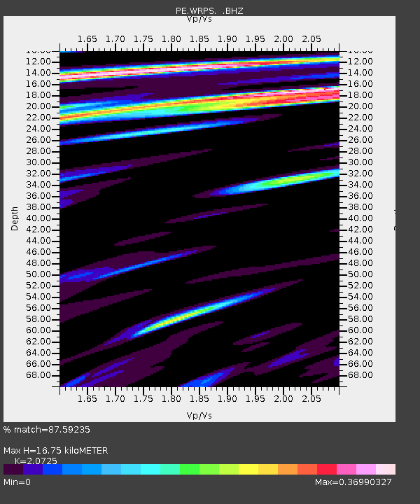
WRPS We R Penn State - Earthquake Result Viewer

Earthquake location: Northern Mid-Atlantic Ridge
Earthquake latitude/longitude: 47.0/-27.3
Earthquake time(UTC): 2008/12/19 (354) 08:31:51 GMT
Earthquake Depth: 2.0 km
Earthquake Magnitude: 5.8 MB, 5.6 MS, 5.9 MW, 5.8 MW
Earthquake Catalog/Contributor: WHDF/NEIC
Network: PE Penn State Network
Station: WRPS We R Penn State
Lat/Lon: 40.79 N/77.87 W
Elevation: 320 m
Distance: 36.4 deg
Az: 279.099 deg
Baz: 62.891 deg
Ray Param: 0.07670006
Estimated Moho Depth: 16.75 km
Estimated Crust Vp/Vs: 2.07
Assumed Crust Vp: 6.121 km/s
Estimated Crust Vs: 2.953 km/s
Estimated Crust Poisson's Ratio: 0.35
Radial Match: 87.59235 %
Radial Bump: 400
Transverse Match: 66.20501 %
Transverse Bump: 400
SOD ConfigId: 2658
Insert Time: 2010-02-26 14:56:23.337 +0000
GWidth: 2.5
Max Bumps: 400
Tol: 0.001

Signal To Noise

ChannelStoNSTALTA
PE:WRPS: :BHZ:20081219T08:38:26.271007Z4.91884768.703876E-71.769495E-7
PE:WRPS: :BHN:20081219T08:38:26.271007Z1.5503672.410583E-71.5548467E-7
PE:WRPS: :BHE:20081219T08:38:26.271007Z3.07354023.332827E-71.08436105E-7
Arrivals
Ps3.1 SECOND
PpPs7.9 SECOND
PsPs/PpSs11 SECOND