You are here: Home > Network List > KN - Kyrgyz Seismic Telemetry Network Stations List
> Station USP KN.USP > Earthquake Result Viewer
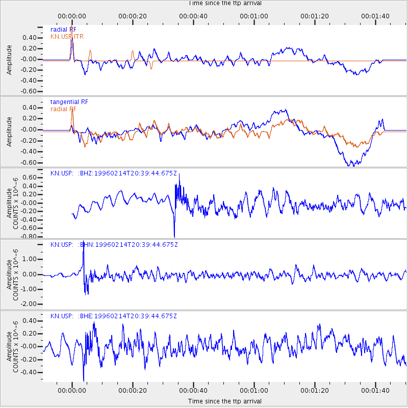
USP KN.USP - Earthquake Result Viewer
*The percent match for this event was below the threshold and hence no stack was calculated.
| Earthquake location: |
Kuril Islands |
| Earthquake latitude/longitude: |
45.4/150.4 |
| Earthquake time(UTC): |
1996/02/14 (045) 20:31:06 GMT |
| Earthquake Depth: |
33 km |
| Earthquake Magnitude: |
5.9 MB, 5.2 MS, 5.8 UNKNOWN, 5.8 MW |
| Earthquake Catalog/Contributor: |
WHDF/NEIC |
|
| Network: |
KN Kyrgyz Seismic Telemetry Network |
| Station: |
USP KN.USP |
| Lat/Lon: |
43.27 N/74.50 E |
| Elevation: |
740 m |
|
| Distance: |
52.4 deg |
| Az: |
296.599 deg |
| Baz: |
59.615 deg |
| Ray Param: |
$rayparam |
*The percent match for this event was below the threshold and hence was not used in the summary stack. |
|
| Radial Match: |
58.18941 % |
| Radial Bump: |
400 |
| Transverse Match: |
49.25757 % |
| Transverse Bump: |
400 |
| SOD ConfigId: |
4480 |
| Insert Time: |
2010-03-08 22:28:31.314 +0000 |
| GWidth: |
2.5 |
| Max Bumps: |
400 |
| Tol: |
0.001 |
|
Signal To Noise
| Channel | StoN | STA | LTA |
| KN:USP: :BHN:19960214T20:39:44.675Z | 9.2390375 | 5.6222854E-7 | 6.085358E-8 |
| KN:USP: :BHE:19960214T20:39:44.675Z | 1.3225915 | 1.6394985E-7 | 1.2396107E-7 |
| KN:USP: :BHZ:19960214T20:39:44.675Z | 1.3740174 | 2.1384311E-7 | 1.5563349E-7 |
| Arrivals |
| Ps | |
| PpPs | |
| PsPs/PpSs | |


