You are here: Home > Network List > GS - US Geological Survey Networks Stations List
> Station DEC05 Decatur Surface Seismic Site, Decatur, IL, USA > Earthquake Result Viewer
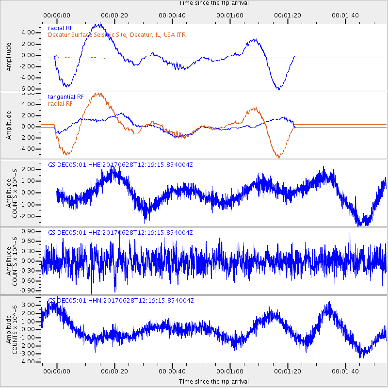
DEC05 Decatur Surface Seismic Site, Decatur, IL, USA - Earthquake Result Viewer
*The percent match for this event was below the threshold and hence no stack was calculated.
| Earthquake location: |
Kuril Islands |
| Earthquake latitude/longitude: |
43.7/148.0 |
| Earthquake time(UTC): |
2017/06/28 (179) 12:07:30 GMT |
| Earthquake Depth: |
49 km |
| Earthquake Magnitude: |
5.4 Mww |
| Earthquake Catalog/Contributor: |
NEIC PDE/us |
|
| Network: |
GS US Geological Survey Networks |
| Station: |
DEC05 Decatur Surface Seismic Site, Decatur, IL, USA |
| Lat/Lon: |
39.87 N/88.87 W |
| Elevation: |
216 m |
|
| Distance: |
82.3 deg |
| Az: |
40.556 deg |
| Baz: |
322.224 deg |
| Ray Param: |
$rayparam |
*The percent match for this event was below the threshold and hence was not used in the summary stack. |
|
| Radial Match: |
52.684742 % |
| Radial Bump: |
400 |
| Transverse Match: |
44.449516 % |
| Transverse Bump: |
400 |
| SOD ConfigId: |
2140511 |
| Insert Time: |
2017-07-12 04:03:00.856 +0000 |
| GWidth: |
2.5 |
| Max Bumps: |
400 |
| Tol: |
0.001 |
|
Signal To Noise
| Channel | StoN | STA | LTA |
| GS:DEC05:01:HHZ:20170628T12:19:15.854004Z | 1.0935477 | 2.474436E-7 | 2.2627603E-7 |
| GS:DEC05:01:HHN:20170628T12:19:15.854004Z | 3.403216 | 3.10085E-6 | 9.1115294E-7 |
| GS:DEC05:01:HHE:20170628T12:19:15.854004Z | 1.8592768 | 1.6445088E-6 | 8.8448843E-7 |
| Arrivals |
| Ps | |
| PpPs | |
| PsPs/PpSs | |


