You are here: Home > Network List > GS - US Geological Survey Networks Stations List
> Station KAN13 Rinehart Farm > Earthquake Result Viewer
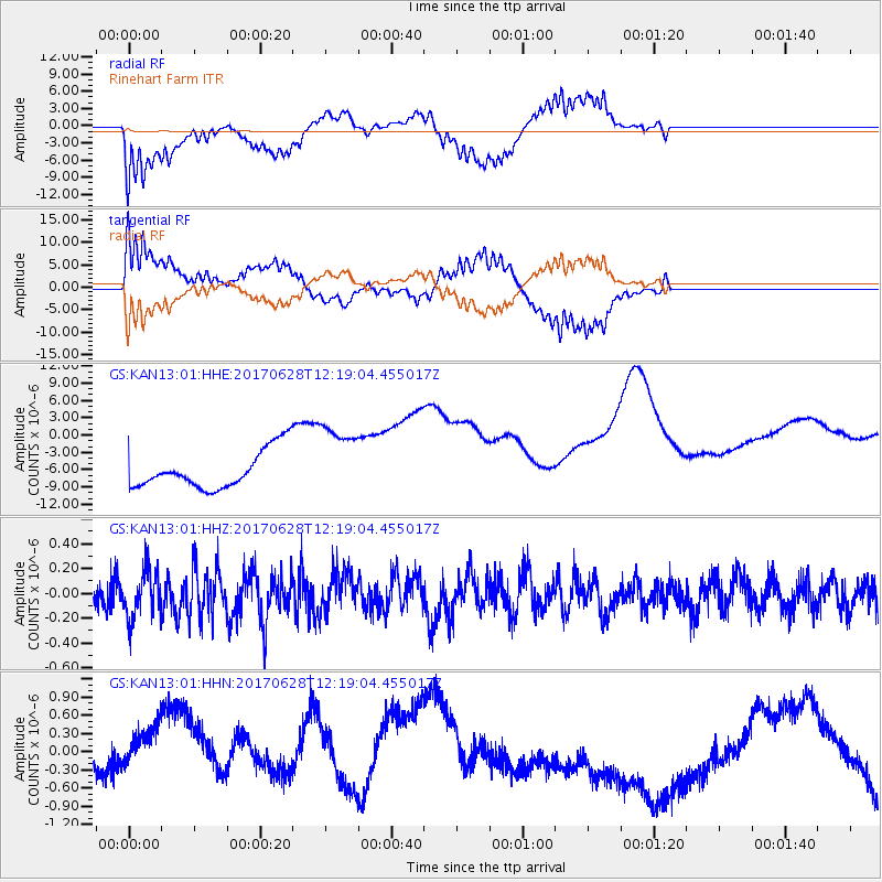
KAN13 Rinehart Farm - Earthquake Result Viewer
*The percent match for this event was below the threshold and hence no stack was calculated.
| Earthquake location: |
Kuril Islands |
| Earthquake latitude/longitude: |
43.7/148.0 |
| Earthquake time(UTC): |
2017/06/28 (179) 12:07:30 GMT |
| Earthquake Depth: |
49 km |
| Earthquake Magnitude: |
5.4 Mww |
| Earthquake Catalog/Contributor: |
NEIC PDE/us |
|
| Network: |
GS US Geological Survey Networks |
| Station: |
KAN13 Rinehart Farm |
| Lat/Lon: |
37.01 N/97.48 W |
| Elevation: |
340 m |
|
| Distance: |
80.1 deg |
| Az: |
47.651 deg |
| Baz: |
317.972 deg |
| Ray Param: |
$rayparam |
*The percent match for this event was below the threshold and hence was not used in the summary stack. |
|
| Radial Match: |
60.88173 % |
| Radial Bump: |
400 |
| Transverse Match: |
60.841393 % |
| Transverse Bump: |
400 |
| SOD ConfigId: |
2140511 |
| Insert Time: |
2017-07-12 04:03:20.237 +0000 |
| GWidth: |
2.5 |
| Max Bumps: |
400 |
| Tol: |
0.001 |
|
Signal To Noise
| Channel | StoN | STA | LTA |
| GS:KAN13:01:HHZ:20170628T12:19:04.455017Z | 1.6812797 | 1.8787846E-7 | 1.117473E-7 |
| GS:KAN13:01:HHN:20170628T12:19:04.455017Z | 2.268937 | 9.448161E-7 | 4.164135E-7 |
| GS:KAN13:01:HHE:20170628T12:19:04.455017Z | 2.062596 | 6.7180913E-6 | 3.2571047E-6 |
| Arrivals |
| Ps | |
| PpPs | |
| PsPs/PpSs | |


