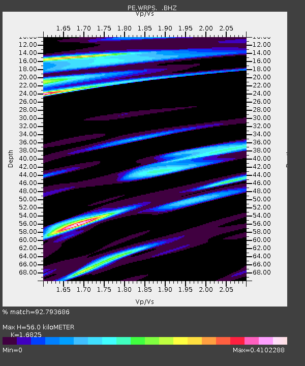
WRPS We R Penn State - Earthquake Result Viewer
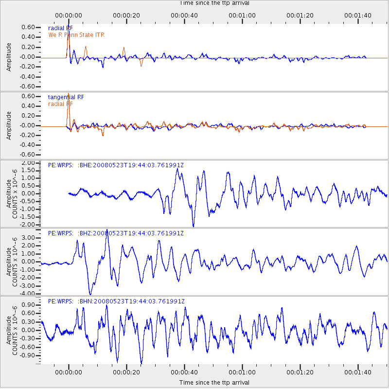
Earthquake location: Central Mid-Atlantic Ridge
Earthquake latitude/longitude: 7.3/-34.9
Earthquake time(UTC): 2008/05/23 (144) 19:35:34 GMT
Earthquake Depth: 9.0 km
Earthquake Magnitude: 6.0 MB, 6.4 MS, 6.5 MW, 6.5 MW
Earthquake Catalog/Contributor: WHDF/NEIC
Network: PE Penn State Network
Station: WRPS We R Penn State
Lat/Lon: 40.79 N/77.87 W
Elevation: 320 m
Distance: 50.7 deg
Az: 318.031 deg
Baz: 119.105 deg
Ray Param: 0.06788316
Estimated Moho Depth: 56.0 km
Estimated Crust Vp/Vs: 1.68
Assumed Crust Vp: 6.121 km/s
Estimated Crust Vs: 3.638 km/s
Estimated Crust Poisson's Ratio: 0.23
Radial Match: 92.793686 %
Radial Bump: 342
Transverse Match: 67.214005 %
Transverse Bump: 400
SOD ConfigId: 2504
Insert Time: 2010-02-26 14:56:26.285 +0000
GWidth: 2.5
Max Bumps: 400
Tol: 0.001

Signal To Noise

ChannelStoNSTALTA
PE:WRPS: :BHZ:20080523T19:44:03.761991Z5.8475131.0549473E-61.8040957E-7
PE:WRPS: :BHN:20080523T19:44:03.761991Z1.35897612.7855015E-72.049706E-7
PE:WRPS: :BHE:20080523T19:44:03.761991Z2.90657764.689309E-71.6133438E-7
Arrivals
Ps6.6 SECOND
PpPs23 SECOND
PsPs/PpSs30 SECOND