You are here: Home > Network List > IW - Intermountain West Stations List
> Station DLMT Dillon, Montana, USA > Earthquake Result Viewer
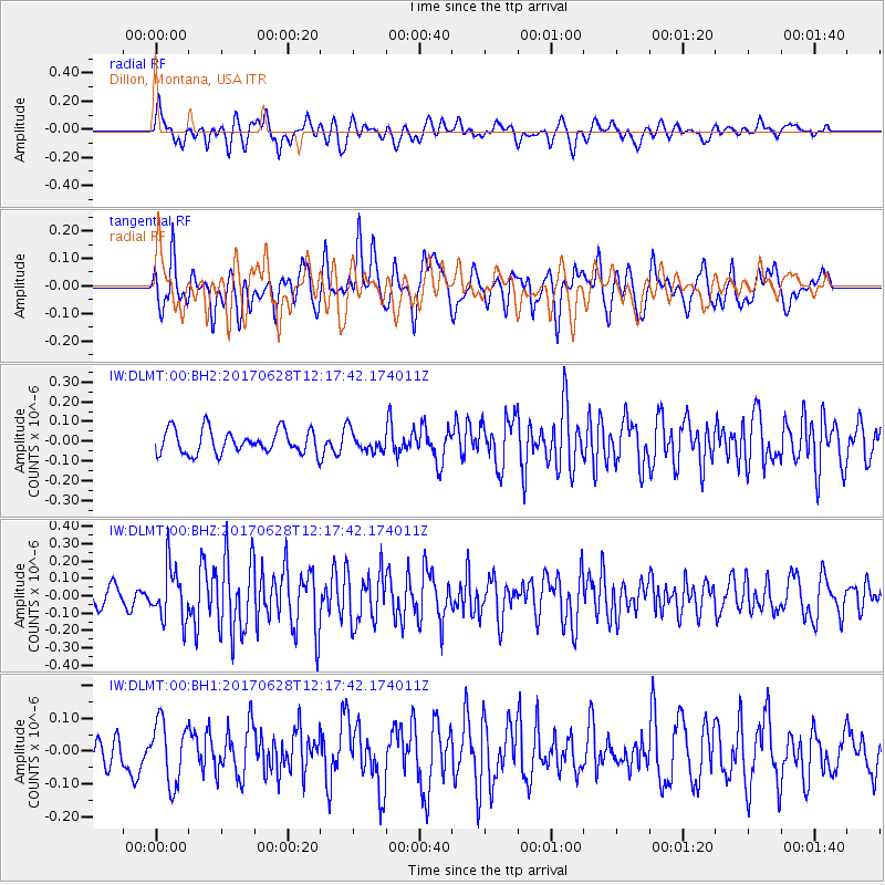
DLMT Dillon, Montana, USA - Earthquake Result Viewer
*The percent match for this event was below the threshold and hence no stack was calculated.
| Earthquake location: |
Kuril Islands |
| Earthquake latitude/longitude: |
43.7/148.0 |
| Earthquake time(UTC): |
2017/06/28 (179) 12:07:30 GMT |
| Earthquake Depth: |
49 km |
| Earthquake Magnitude: |
5.4 Mww |
| Earthquake Catalog/Contributor: |
NEIC PDE/us |
|
| Network: |
IW Intermountain West |
| Station: |
DLMT Dillon, Montana, USA |
| Lat/Lon: |
45.36 N/112.60 W |
| Elevation: |
1569 m |
|
| Distance: |
66.1 deg |
| Az: |
49.51 deg |
| Baz: |
308.538 deg |
| Ray Param: |
$rayparam |
*The percent match for this event was below the threshold and hence was not used in the summary stack. |
|
| Radial Match: |
53.943367 % |
| Radial Bump: |
400 |
| Transverse Match: |
50.80189 % |
| Transverse Bump: |
400 |
| SOD ConfigId: |
2140511 |
| Insert Time: |
2017-07-12 04:06:40.607 +0000 |
| GWidth: |
2.5 |
| Max Bumps: |
400 |
| Tol: |
0.001 |
|
Signal To Noise
| Channel | StoN | STA | LTA |
| IW:DLMT:00:BHZ:20170628T12:17:42.174011Z | 2.0841153 | 1.478883E-7 | 7.095975E-8 |
| IW:DLMT:00:BH1:20170628T12:17:42.174011Z | 1.3371689 | 9.373812E-8 | 7.010193E-8 |
| IW:DLMT:00:BH2:20170628T12:17:42.174011Z | 0.8551551 | 5.1713624E-8 | 6.04728E-8 |
| Arrivals |
| Ps | |
| PpPs | |
| PsPs/PpSs | |


