You are here: Home > Network List > TA - USArray Transportable Network (new EarthScope stations) Stations List
> Station C17K DeLong Mountains, AK, USA > Earthquake Result Viewer
C17K DeLong Mountains, AK, USA - Earthquake Result Viewer
| Earthquake location: |
Tajikistan |
| Earthquake latitude/longitude: |
39.1/70.9 |
| Earthquake time(UTC): |
2020/07/04 (186) 09:53:00 GMT |
| Earthquake Depth: |
10 km |
| Earthquake Magnitude: |
5.4 Mww |
| Earthquake Catalog/Contributor: |
NEIC PDE/us |
|
| Network: |
TA USArray Transportable Network (new EarthScope stations) |
| Station: |
C17K DeLong Mountains, AK, USA |
| Lat/Lon: |
68.48 N/163.18 W |
| Elevation: |
498 m |
|
| Distance: |
65.5 deg |
| Az: |
19.175 deg |
| Baz: |
316.137 deg |
| Ray Param: |
0.05823202 |
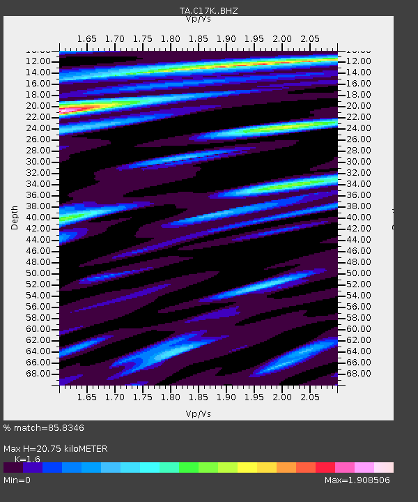
| Estimated Moho Depth: |
20.75 km |
| Estimated Crust Vp/Vs: |
1.60 |
| Assumed Crust Vp: |
5.906 km/s |
| Estimated Crust Vs: |
3.692 km/s |
| Estimated Crust Poisson's Ratio: |
0.18 |
|
| Radial Match: |
85.8346 % |
| Radial Bump: |
400 |
| Transverse Match: |
70.36808 % |
| Transverse Bump: |
400 |
| SOD ConfigId: |
21709731 |
| Insert Time: |
2020-07-18 10:07:33.774 +0000 |
| GWidth: |
2.5 |
| Max Bumps: |
400 |
| Tol: |
0.001 |
|

Signal To Noise
| Channel | StoN | STA | LTA |
| TA:C17K: :BHZ:20200704T10:03:12.824972Z | 7.739304 | 5.9038126E-7 | 7.628351E-8 |
| TA:C17K: :BHN:20200704T10:03:12.824972Z | 2.678547 | 2.1457778E-7 | 8.0109764E-8 |
| TA:C17K: :BHE:20200704T10:03:12.824972Z | 2.5425189 | 1.6137035E-7 | 6.34687E-8 |
| Arrivals |
| Ps | 2.2 SECOND |
| PpPs | 8.8 SECOND |
| PsPs/PpSs | 11 SECOND |


