You are here: Home > Network List > TA - USArray Transportable Network (new EarthScope stations) Stations List
> Station E18K Tukpahlearik Creek, AK, USA > Earthquake Result Viewer
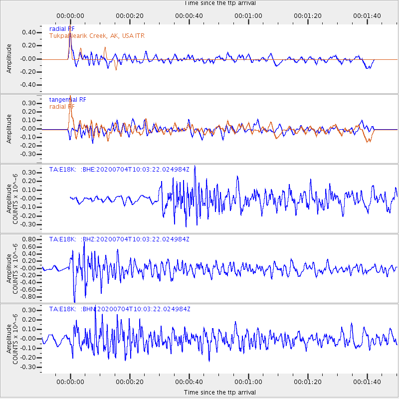
E18K Tukpahlearik Creek, AK, USA - Earthquake Result Viewer
*The percent match for this event was below the threshold and hence no stack was calculated.
| Earthquake location: |
Tajikistan |
| Earthquake latitude/longitude: |
39.1/70.9 |
| Earthquake time(UTC): |
2020/07/04 (186) 09:53:00 GMT |
| Earthquake Depth: |
10 km |
| Earthquake Magnitude: |
5.4 Mww |
| Earthquake Catalog/Contributor: |
NEIC PDE/us |
|
| Network: |
TA USArray Transportable Network (new EarthScope stations) |
| Station: |
E18K Tukpahlearik Creek, AK, USA |
| Lat/Lon: |
67.42 N/160.60 W |
| Elevation: |
297 m |
|
| Distance: |
66.9 deg |
| Az: |
19.178 deg |
| Baz: |
318.523 deg |
| Ray Param: |
$rayparam |
*The percent match for this event was below the threshold and hence was not used in the summary stack. |
|
| Radial Match: |
71.04333 % |
| Radial Bump: |
400 |
| Transverse Match: |
70.25114 % |
| Transverse Bump: |
400 |
| SOD ConfigId: |
21709731 |
| Insert Time: |
2020-07-18 10:07:57.399 +0000 |
| GWidth: |
2.5 |
| Max Bumps: |
400 |
| Tol: |
0.001 |
|
Signal To Noise
| Channel | StoN | STA | LTA |
| TA:E18K: :BHZ:20200704T10:03:22.024984Z | 8.476553 | 3.8794204E-7 | 4.5766484E-8 |
| TA:E18K: :BHN:20200704T10:03:22.024984Z | 2.472514 | 8.697437E-8 | 3.517649E-8 |
| TA:E18K: :BHE:20200704T10:03:22.024984Z | 4.025847 | 1.1197251E-7 | 2.7813405E-8 |
| Arrivals |
| Ps | |
| PpPs | |
| PsPs/PpSs | |


