You are here: Home > Network List > TA - USArray Transportable Network (new EarthScope stations) Stations List
> Station F15K North Star Ditch, AK, USA > Earthquake Result Viewer
F15K North Star Ditch, AK, USA - Earthquake Result Viewer
| Earthquake location: |
Tajikistan |
| Earthquake latitude/longitude: |
39.1/70.9 |
| Earthquake time(UTC): |
2020/07/04 (186) 09:53:00 GMT |
| Earthquake Depth: |
10 km |
| Earthquake Magnitude: |
5.4 Mww |
| Earthquake Catalog/Contributor: |
NEIC PDE/us |
|
| Network: |
TA USArray Transportable Network (new EarthScope stations) |
| Station: |
F15K North Star Ditch, AK, USA |
| Lat/Lon: |
65.71 N/164.65 W |
| Elevation: |
388 m |
|
| Distance: |
67.1 deg |
| Az: |
21.738 deg |
| Baz: |
315.813 deg |
| Ray Param: |
0.057179756 |
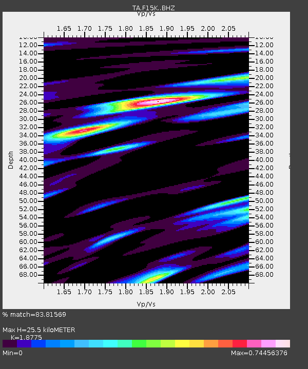
| Estimated Moho Depth: |
25.5 km |
| Estimated Crust Vp/Vs: |
1.88 |
| Assumed Crust Vp: |
6.276 km/s |
| Estimated Crust Vs: |
3.343 km/s |
| Estimated Crust Poisson's Ratio: |
0.30 |
|
| Radial Match: |
83.81569 % |
| Radial Bump: |
400 |
| Transverse Match: |
73.72518 % |
| Transverse Bump: |
400 |
| SOD ConfigId: |
21709731 |
| Insert Time: |
2020-07-18 10:08:14.379 +0000 |
| GWidth: |
2.5 |
| Max Bumps: |
400 |
| Tol: |
0.001 |
|

Signal To Noise
| Channel | StoN | STA | LTA |
| TA:F15K: :BHZ:20200704T10:03:23.050008Z | 7.503327 | 4.0753585E-7 | 5.431402E-8 |
| TA:F15K: :BHN:20200704T10:03:23.050008Z | 3.2212594 | 1.4131602E-7 | 4.3869804E-8 |
| TA:F15K: :BHE:20200704T10:03:23.050008Z | 3.9369633 | 1.0868492E-7 | 2.7606283E-8 |
| Arrivals |
| Ps | 3.7 SECOND |
| PpPs | 11 SECOND |
| PsPs/PpSs | 15 SECOND |


