You are here: Home > Network List > NE - New England Seismic Network Stations List
> Station EMMW Machias, ME, USA > Earthquake Result Viewer
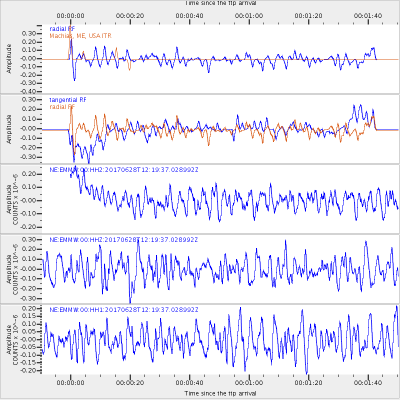
EMMW Machias, ME, USA - Earthquake Result Viewer
*The percent match for this event was below the threshold and hence no stack was calculated.
| Earthquake location: |
Kuril Islands |
| Earthquake latitude/longitude: |
43.7/148.0 |
| Earthquake time(UTC): |
2017/06/28 (179) 12:07:30 GMT |
| Earthquake Depth: |
49 km |
| Earthquake Magnitude: |
5.4 Mww |
| Earthquake Catalog/Contributor: |
NEIC PDE/us |
|
| Network: |
NE New England Seismic Network |
| Station: |
EMMW Machias, ME, USA |
| Lat/Lon: |
44.71 N/67.46 W |
| Elevation: |
35 m |
|
| Distance: |
86.5 deg |
| Az: |
24.467 deg |
| Baz: |
335.092 deg |
| Ray Param: |
$rayparam |
*The percent match for this event was below the threshold and hence was not used in the summary stack. |
|
| Radial Match: |
55.157803 % |
| Radial Bump: |
400 |
| Transverse Match: |
36.876995 % |
| Transverse Bump: |
400 |
| SOD ConfigId: |
2140511 |
| Insert Time: |
2017-07-12 04:07:49.185 +0000 |
| GWidth: |
2.5 |
| Max Bumps: |
400 |
| Tol: |
0.001 |
|
Signal To Noise
| Channel | StoN | STA | LTA |
| NE:EMMW:00:HHZ:20170628T12:19:37.028992Z | 1.0198244 | 9.273766E-8 | 9.093493E-8 |
| NE:EMMW:00:HH1:20170628T12:19:37.028992Z | 1.189982 | 8.346405E-8 | 7.013892E-8 |
| NE:EMMW:00:HH2:20170628T12:19:37.028992Z | 0.89816856 | 8.050321E-8 | 8.9630404E-8 |
| Arrivals |
| Ps | |
| PpPs | |
| PsPs/PpSs | |


