You are here: Home > Network List > TA - USArray Transportable Network (new EarthScope stations) Stations List
> Station L15K Ungalak Mountain, AK, USA > Earthquake Result Viewer
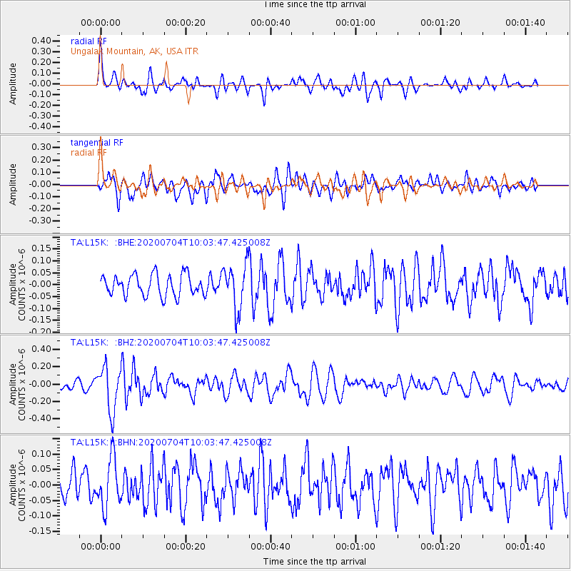
L15K Ungalak Mountain, AK, USA - Earthquake Result Viewer
*The percent match for this event was below the threshold and hence no stack was calculated.
| Earthquake location: |
Tajikistan |
| Earthquake latitude/longitude: |
39.1/70.9 |
| Earthquake time(UTC): |
2020/07/04 (186) 09:53:00 GMT |
| Earthquake Depth: |
10 km |
| Earthquake Magnitude: |
5.4 Mww |
| Earthquake Catalog/Contributor: |
NEIC PDE/us |
|
| Network: |
TA USArray Transportable Network (new EarthScope stations) |
| Station: |
L15K Ungalak Mountain, AK, USA |
| Lat/Lon: |
61.68 N/161.49 W |
| Elevation: |
219 m |
|
| Distance: |
71.0 deg |
| Az: |
23.547 deg |
| Baz: |
319.293 deg |
| Ray Param: |
$rayparam |
*The percent match for this event was below the threshold and hence was not used in the summary stack. |
|
| Radial Match: |
69.539604 % |
| Radial Bump: |
400 |
| Transverse Match: |
66.83963 % |
| Transverse Bump: |
400 |
| SOD ConfigId: |
21709731 |
| Insert Time: |
2020-07-18 10:09:16.205 +0000 |
| GWidth: |
2.5 |
| Max Bumps: |
400 |
| Tol: |
0.001 |
|
Signal To Noise
| Channel | StoN | STA | LTA |
| TA:L15K: :BHZ:20200704T10:03:47.425008Z | 5.1390953 | 2.601049E-7 | 5.061297E-8 |
| TA:L15K: :BHN:20200704T10:03:47.425008Z | 1.8713728 | 8.144512E-8 | 4.352159E-8 |
| TA:L15K: :BHE:20200704T10:03:47.425008Z | 2.1646943 | 9.5561596E-8 | 4.4145537E-8 |
| Arrivals |
| Ps | |
| PpPs | |
| PsPs/PpSs | |


