You are here: Home > Network List > US - United States National Seismic Network Stations List
> Station AMTX Amarillo, Texas, USA > Earthquake Result Viewer
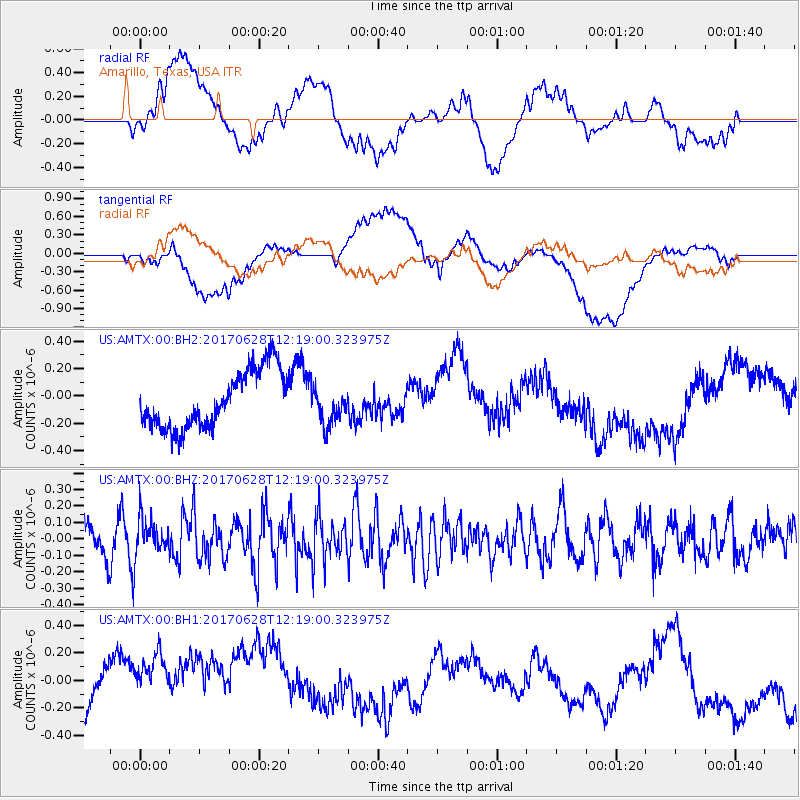
AMTX Amarillo, Texas, USA - Earthquake Result Viewer
*The percent match for this event was below the threshold and hence no stack was calculated.
| Earthquake location: |
Kuril Islands |
| Earthquake latitude/longitude: |
43.7/148.0 |
| Earthquake time(UTC): |
2017/06/28 (179) 12:07:30 GMT |
| Earthquake Depth: |
49 km |
| Earthquake Magnitude: |
5.4 Mww |
| Earthquake Catalog/Contributor: |
NEIC PDE/us |
|
| Network: |
US United States National Seismic Network |
| Station: |
AMTX Amarillo, Texas, USA |
| Lat/Lon: |
34.53 N/101.41 W |
| Elevation: |
1010 m |
|
| Distance: |
79.8 deg |
| Az: |
51.742 deg |
| Baz: |
316.398 deg |
| Ray Param: |
$rayparam |
*The percent match for this event was below the threshold and hence was not used in the summary stack. |
|
| Radial Match: |
16.84991 % |
| Radial Bump: |
400 |
| Transverse Match: |
24.129099 % |
| Transverse Bump: |
400 |
| SOD ConfigId: |
2140511 |
| Insert Time: |
2017-07-12 04:10:01.410 +0000 |
| GWidth: |
2.5 |
| Max Bumps: |
400 |
| Tol: |
0.001 |
|
Signal To Noise
| Channel | StoN | STA | LTA |
| US:AMTX:00:BHZ:20170628T12:19:00.323975Z | 1.465702 | 1.153541E-7 | 7.8702286E-8 |
| US:AMTX:00:BH1:20170628T12:19:00.323975Z | 1.2885853 | 3.753862E-7 | 2.9131652E-7 |
| US:AMTX:00:BH2:20170628T12:19:00.323975Z | 0.760971 | 1.6345497E-7 | 2.1479788E-7 |
| Arrivals |
| Ps | |
| PpPs | |
| PsPs/PpSs | |


