You are here: Home > Network List > KN - Kyrgyz Seismic Telemetry Network Stations List
> Station USP KN.USP > Earthquake Result Viewer
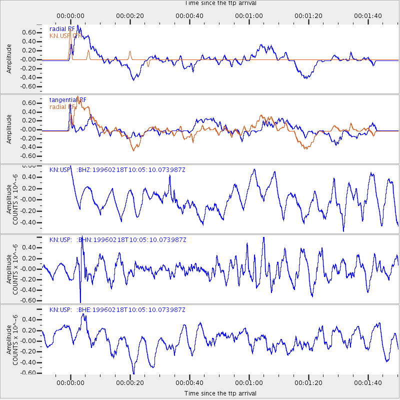
USP KN.USP - Earthquake Result Viewer
*The percent match for this event was below the threshold and hence no stack was calculated.
| Earthquake location: |
Mindoro, Philippines |
| Earthquake latitude/longitude: |
13.9/120.8 |
| Earthquake time(UTC): |
1996/02/18 (049) 09:57:16 GMT |
| Earthquake Depth: |
242 km |
| Earthquake Magnitude: |
5.6 UNKNOWN, 5.4 MB |
| Earthquake Catalog/Contributor: |
WHDF/NEIC |
|
| Network: |
KN Kyrgyz Seismic Telemetry Network |
| Station: |
USP KN.USP |
| Lat/Lon: |
43.27 N/74.50 E |
| Elevation: |
740 m |
|
| Distance: |
49.2 deg |
| Az: |
315.805 deg |
| Baz: |
112.055 deg |
| Ray Param: |
$rayparam |
*The percent match for this event was below the threshold and hence was not used in the summary stack. |
|
| Radial Match: |
36.005394 % |
| Radial Bump: |
400 |
| Transverse Match: |
30.845062 % |
| Transverse Bump: |
400 |
| SOD ConfigId: |
4480 |
| Insert Time: |
2010-03-08 22:30:04.266 +0000 |
| GWidth: |
2.5 |
| Max Bumps: |
400 |
| Tol: |
0.001 |
|
Signal To Noise
| Channel | StoN | STA | LTA |
| KN:USP: :BHN:19960218T10:05:10.073987Z | 1.9954091 | 2.5946505E-7 | 1.3003101E-7 |
| KN:USP: :BHE:19960218T10:05:10.073987Z | 2.1844127 | 3.890976E-7 | 1.781246E-7 |
| KN:USP: :BHZ:19960218T10:05:10.073987Z | 0.7402723 | 1.3838485E-7 | 1.8693777E-7 |
| Arrivals |
| Ps | |
| PpPs | |
| PsPs/PpSs | |


