You are here: Home > Network List > US - United States National Seismic Network Stations List
> Station MSO Missoula, Montana, USA > Earthquake Result Viewer
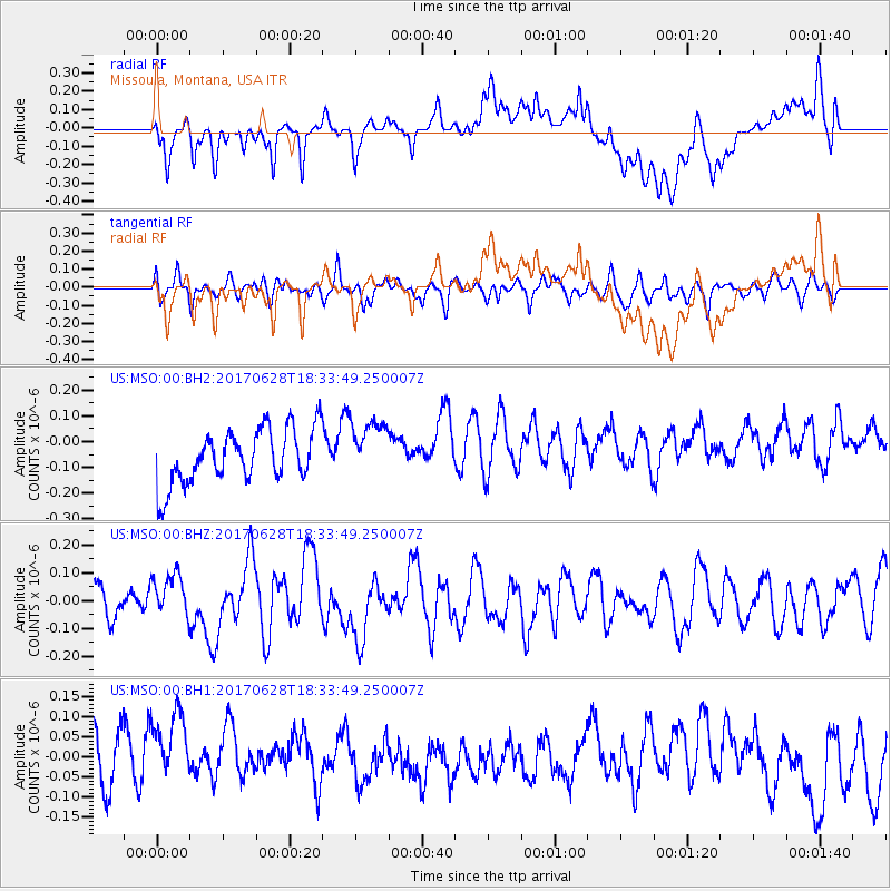
MSO Missoula, Montana, USA - Earthquake Result Viewer
*The percent match for this event was below the threshold and hence no stack was calculated.
| Earthquake location: |
Kermadec Islands, New Zealand |
| Earthquake latitude/longitude: |
-30.4/-177.7 |
| Earthquake time(UTC): |
2017/06/28 (179) 18:20:53 GMT |
| Earthquake Depth: |
10 km |
| Earthquake Magnitude: |
6.0 Mwb |
| Earthquake Catalog/Contributor: |
NEIC PDE/us |
|
| Network: |
US United States National Seismic Network |
| Station: |
MSO Missoula, Montana, USA |
| Lat/Lon: |
46.83 N/113.94 W |
| Elevation: |
1264 m |
|
| Distance: |
96.0 deg |
| Az: |
38.246 deg |
| Baz: |
231.152 deg |
| Ray Param: |
$rayparam |
*The percent match for this event was below the threshold and hence was not used in the summary stack. |
|
| Radial Match: |
50.79259 % |
| Radial Bump: |
400 |
| Transverse Match: |
49.25556 % |
| Transverse Bump: |
400 |
| SOD ConfigId: |
2140511 |
| Insert Time: |
2017-07-12 10:18:18.936 +0000 |
| GWidth: |
2.5 |
| Max Bumps: |
400 |
| Tol: |
0.001 |
|
Signal To Noise
| Channel | StoN | STA | LTA |
| US:MSO:00:BHZ:20170628T18:33:49.250007Z | 1.1724408 | 7.690974E-8 | 6.559798E-8 |
| US:MSO:00:BH1:20170628T18:33:49.250007Z | 1.5080247 | 1.16847424E-7 | 7.7483755E-8 |
| US:MSO:00:BH2:20170628T18:33:49.250007Z | 1.0777037 | 1.1254165E-7 | 1.0442727E-7 |
| Arrivals |
| Ps | |
| PpPs | |
| PsPs/PpSs | |


