You are here: Home > Network List > TA - USArray Transportable Network (new EarthScope stations) Stations List
> Station L15K Ungalak Mountain, AK, USA > Earthquake Result Viewer
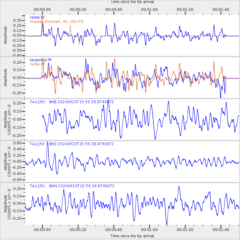
L15K Ungalak Mountain, AK, USA - Earthquake Result Viewer
*The percent match for this event was below the threshold and hence no stack was calculated.
| Earthquake location: |
Solomon Islands |
| Earthquake latitude/longitude: |
-9.4/156.0 |
| Earthquake time(UTC): |
2020/06/20 (172) 15:45:10 GMT |
| Earthquake Depth: |
8.0 km |
| Earthquake Magnitude: |
5.4 Mww |
| Earthquake Catalog/Contributor: |
NEIC PDE/us |
|
| Network: |
TA USArray Transportable Network (new EarthScope stations) |
| Station: |
L15K Ungalak Mountain, AK, USA |
| Lat/Lon: |
61.68 N/161.49 W |
| Elevation: |
219 m |
|
| Distance: |
78.2 deg |
| Az: |
19.211 deg |
| Baz: |
222.902 deg |
| Ray Param: |
$rayparam |
*The percent match for this event was below the threshold and hence was not used in the summary stack. |
|
| Radial Match: |
68.49082 % |
| Radial Bump: |
400 |
| Transverse Match: |
57.586346 % |
| Transverse Bump: |
400 |
| SOD ConfigId: |
21709731 |
| Insert Time: |
2020-07-19 15:01:03.906 +0000 |
| GWidth: |
2.5 |
| Max Bumps: |
400 |
| Tol: |
0.001 |
|
Signal To Noise
| Channel | StoN | STA | LTA |
| TA:L15K: :BHZ:20200620T15:56:38.874997Z | 3.742973 | 2.3540565E-7 | 6.289269E-8 |
| TA:L15K: :BHN:20200620T15:56:38.874997Z | 1.0614427 | 6.414444E-8 | 6.043137E-8 |
| TA:L15K: :BHE:20200620T15:56:38.874997Z | 1.3316901 | 1.0054451E-7 | 7.550143E-8 |
| Arrivals |
| Ps | |
| PpPs | |
| PsPs/PpSs | |


