You are here: Home > Network List > II - Global Seismograph Network (GSN - IRIS/IDA) Stations List
> Station WRAB Tennant Creek, NT, Australia > Earthquake Result Viewer
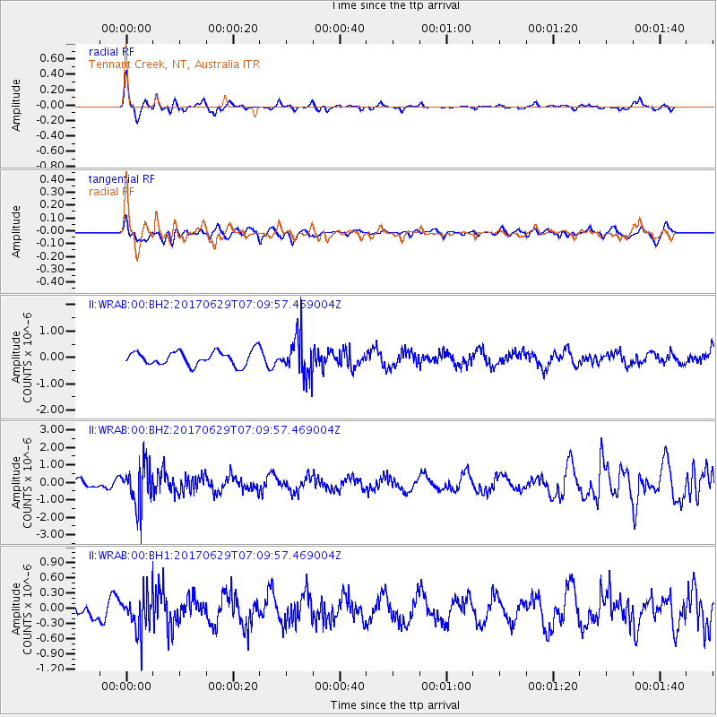
WRAB Tennant Creek, NT, Australia - Earthquake Result Viewer
*The percent match for this event was below the threshold and hence no stack was calculated.
| Earthquake location: |
Kermadec Islands Region |
| Earthquake latitude/longitude: |
-31.1/180.0 |
| Earthquake time(UTC): |
2017/06/29 (180) 07:03:10 GMT |
| Earthquake Depth: |
392 km |
| Earthquake Magnitude: |
6.0 Mww |
| Earthquake Catalog/Contributor: |
NEIC PDE/us |
|
| Network: |
II Global Seismograph Network (GSN - IRIS/IDA) |
| Station: |
WRAB Tennant Creek, NT, Australia |
| Lat/Lon: |
19.93 S/134.36 E |
| Elevation: |
366 m |
|
| Distance: |
42.4 deg |
| Az: |
274.059 deg |
| Baz: |
114.569 deg |
| Ray Param: |
$rayparam |
*The percent match for this event was below the threshold and hence was not used in the summary stack. |
|
| Radial Match: |
70.55805 % |
| Radial Bump: |
360 |
| Transverse Match: |
61.263042 % |
| Transverse Bump: |
400 |
| SOD ConfigId: |
2140511 |
| Insert Time: |
2017-07-12 22:56:54.760 +0000 |
| GWidth: |
2.5 |
| Max Bumps: |
400 |
| Tol: |
0.001 |
|
Signal To Noise
| Channel | StoN | STA | LTA |
| II:WRAB:00:BHZ:20170629T07:09:57.469004Z | 4.3910284 | 1.1701021E-6 | 2.6647567E-7 |
| II:WRAB:00:BH1:20170629T07:09:57.469004Z | 2.034666 | 3.5584858E-7 | 1.7489288E-7 |
| II:WRAB:00:BH2:20170629T07:09:57.469004Z | 2.8383832 | 7.4285674E-7 | 2.6171827E-7 |
| Arrivals |
| Ps | |
| PpPs | |
| PsPs/PpSs | |


