You are here: Home > Network List > IU - Global Seismograph Network (GSN - IRIS/USGS) Stations List
> Station JOHN Johnston Island, USA > Earthquake Result Viewer
JOHN Johnston Island, USA - Earthquake Result Viewer
*The percent match for this event was below the threshold and hence no stack was calculated.
| Earthquake location: |
Kermadec Islands Region |
| Earthquake latitude/longitude: |
-31.1/180.0 |
| Earthquake time(UTC): |
2017/06/29 (180) 07:03:10 GMT |
| Earthquake Depth: |
392 km |
| Earthquake Magnitude: |
6.0 Mww |
| Earthquake Catalog/Contributor: |
NEIC PDE/us |
|
| Network: |
IU Global Seismograph Network (GSN - IRIS/USGS) |
| Station: |
JOHN Johnston Island, USA |
| Lat/Lon: |
16.73 N/169.53 W |
| Elevation: |
2.0 m |
|
| Distance: |
48.6 deg |
| Az: |
13.482 deg |
| Baz: |
192.047 deg |
| Ray Param: |
$rayparam |
*The percent match for this event was below the threshold and hence was not used in the summary stack. |
|
| Radial Match: |
56.92742 % |
| Radial Bump: |
400 |
| Transverse Match: |
48.80227 % |
| Transverse Bump: |
400 |
| SOD ConfigId: |
2140511 |
| Insert Time: |
2017-07-12 22:57:05.623 +0000 |
| GWidth: |
2.5 |
| Max Bumps: |
400 |
| Tol: |
0.001 |
|
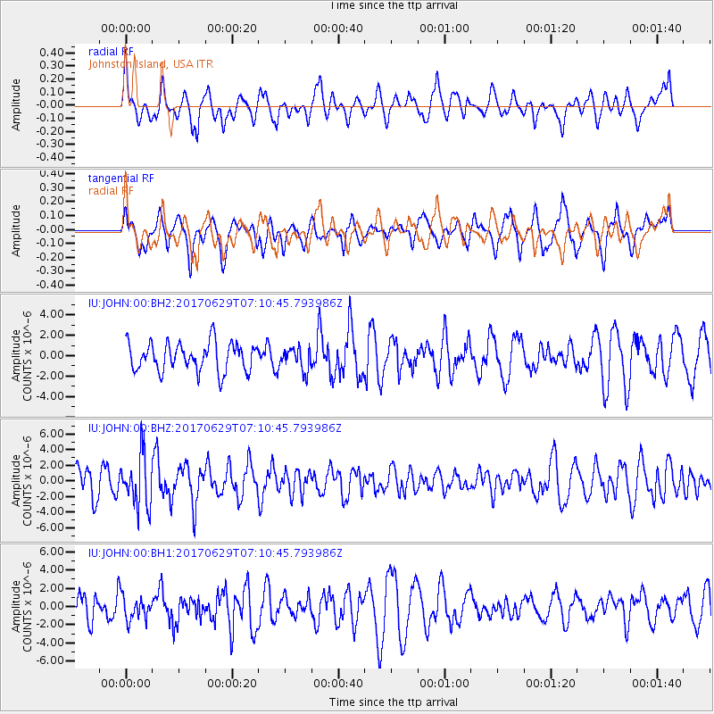
Signal To Noise
| Channel | StoN | STA | LTA |
| IU:JOHN:00:BHZ:20170629T07:10:45.793986Z | 2.3385022 | 3.3232623E-6 | 1.4211071E-6 |
| IU:JOHN:00:BH1:20170629T07:10:45.793986Z | 0.59377974 | 1.2459246E-6 | 2.0982943E-6 |
| IU:JOHN:00:BH2:20170629T07:10:45.793986Z | 0.7688223 | 1.0773443E-6 | 1.4012917E-6 |
| Arrivals |
| Ps | |
| PpPs | |
| PsPs/PpSs | |


