You are here: Home > Network List > TA - USArray Transportable Network (new EarthScope stations) Stations List
> Station F26K Sheenjek River, AK, USA > Earthquake Result Viewer
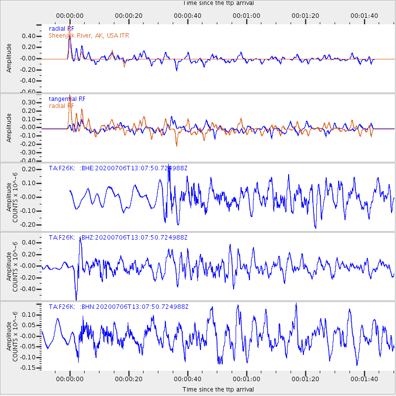
F26K Sheenjek River, AK, USA - Earthquake Result Viewer
*The percent match for this event was below the threshold and hence no stack was calculated.
| Earthquake location: |
Mariana Islands Region |
| Earthquake latitude/longitude: |
21.0/144.8 |
| Earthquake time(UTC): |
2020/07/06 (188) 12:58:04 GMT |
| Earthquake Depth: |
124 km |
| Earthquake Magnitude: |
5.5 Mww |
| Earthquake Catalog/Contributor: |
NEIC PDE/us |
|
| Network: |
TA USArray Transportable Network (new EarthScope stations) |
| Station: |
F26K Sheenjek River, AK, USA |
| Lat/Lon: |
67.69 N/144.15 W |
| Elevation: |
683 m |
|
| Distance: |
63.5 deg |
| Az: |
23.783 deg |
| Baz: |
260.693 deg |
| Ray Param: |
$rayparam |
*The percent match for this event was below the threshold and hence was not used in the summary stack. |
|
| Radial Match: |
70.471245 % |
| Radial Bump: |
400 |
| Transverse Match: |
60.13149 % |
| Transverse Bump: |
400 |
| SOD ConfigId: |
21709731 |
| Insert Time: |
2020-07-20 13:13:46.524 +0000 |
| GWidth: |
2.5 |
| Max Bumps: |
400 |
| Tol: |
0.001 |
|
Signal To Noise
| Channel | StoN | STA | LTA |
| TA:F26K: :BHZ:20200706T13:07:50.724988Z | 6.243685 | 2.5035996E-7 | 4.0098115E-8 |
| TA:F26K: :BHN:20200706T13:07:50.724988Z | 1.397229 | 4.2416932E-8 | 3.0357896E-8 |
| TA:F26K: :BHE:20200706T13:07:50.724988Z | 2.136109 | 1.1000891E-7 | 5.1499672E-8 |
| Arrivals |
| Ps | |
| PpPs | |
| PsPs/PpSs | |


